ZCZC MIATWOAT ALL
TTAA00 KNHC DDHHMM
Tropical Weather Outlook
NWS National Hurricane Center Miami FL
800 AM EDT Tue Oct 25 2022
For the North Atlantic...Caribbean Sea and the Gulf of Mexico:
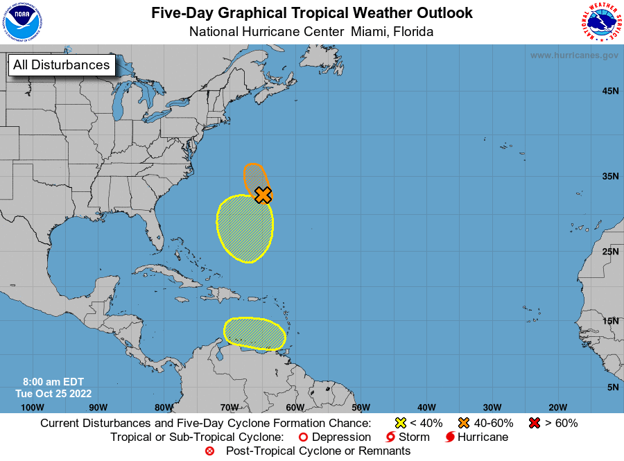
1. Northwestern Atlantic:
Showers and thunderstorms have decreased since yesterday in
association with a well-defined area of low pressure located
just west-northwest of Bermuda. Environmental conditions are
becoming less conducive for development, and the chance of this
system becoming a short-lived tropical depression appears to be
decreasing. The low is expected to move northward towards cooler
waters and into a region of unfavorable upper-level winds by
tonight, which should limit further development. Regardless of
development, periods of locally heavy rainfall and gusty winds are
expected over Bermuda though this morning. Interests in Bermuda
should monitor the progress of this system.
* Formation chance through 48 hours...medium...40 percent.
* Formation chance through 5 days...medium...40 percent.
2. Southwestern Atlantic:
An area of low pressure is expected to form midway between Puerto
Rico and Bermuda in a couple of days. Thereafter, environmental
conditions appear conducive for gradual subtropical development of
this system while it meanders over the southwestern Atlantic through
the weekend.
* Formation chance through 48 hours...low...near 0 percent.
* Formation chance through 5 days...low...30 percent.
3. Eastern Caribbean:
An area of low pressure could form over the eastern Caribbean Sea
by early this weekend. Environmental conditions are forecast to be
conducive for gradual development as the low drifts westward or
west-northwestward over the eastern Caribbean this weekend.
* Formation chance through 48 hours...low...near 0 percent.
* Formation chance through 5 days...low...20 percent.
Forecaster Hagen/Brown