ZCZC MIATWOAT ALL
TTAA00 KNHC DDHHMM
Tropical Weather Outlook
NWS National Hurricane Center Miami FL
800 PM EDT Tue Aug 24 2021
For the North Atlantic...Caribbean Sea and the Gulf of Mexico:
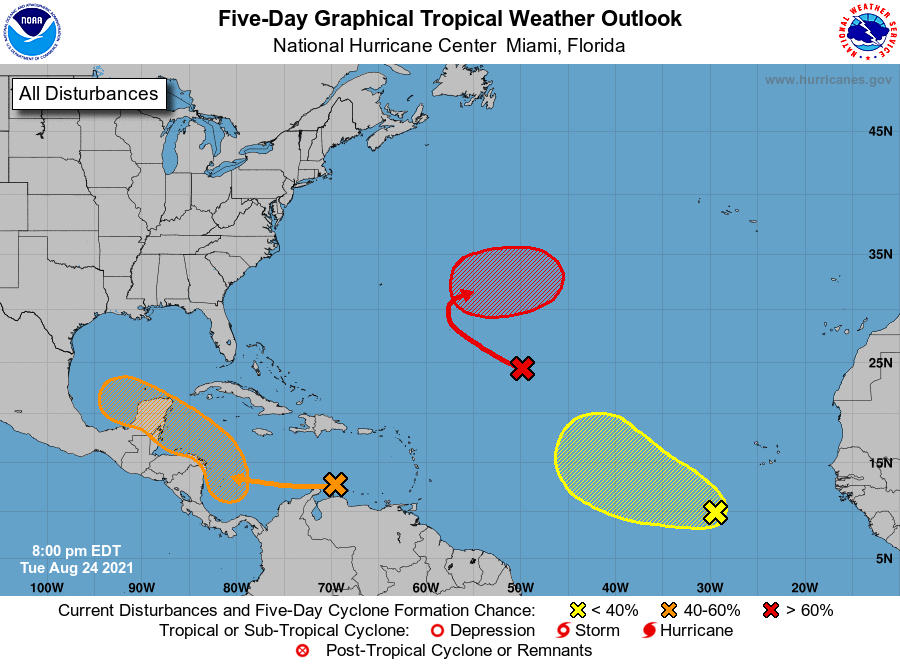
1. A broad area of low pressure is expected to form over the
southwestern Caribbean Sea in a couple of days from a tropical wave
currently located over the central Caribbean Sea. Environmental
conditions are forecast to be conducive for development of the low
if it remains over water, and a tropical depression could form late
this week or this weekend while the system moves northwestward over
the northwestern Caribbean Sea, across the Yucatan Peninsula of
Mexico, and into the southwestern Gulf of Mexico by Sunday.
* Formation chance through 48 hours...low...20 percent.
* Formation chance through 5 days...medium...60 percent.
2. A broad trough of low pressure is producing disorganized showers and
thunderstorms over the central tropical Atlantic about 1000 miles
east-northeast of the northern Leeward Islands. Little development
of this system is expected during the next day or two due to
unfavorable upper-level winds. Afterwards, environmental conditions
are expected to become more conducive for development, and a
tropical depression is likely to form by the end of the week while
the system turns eastward over the central Atlantic.
* Formation chance through 48 hours...low...20 percent.
* Formation chance through 5 days...high...70 percent.
3. A tropical wave over the far eastern tropical Atlantic located
several hundred miles southwest of the Cabo Verde Islands is
producing a concentrated area of showers and thunderstorms. Some
development of this system is possible over the next several days
while it moves west-northwestward at 10 to 15 mph over the eastern
tropical Atlantic. Upper-level winds are forecast to become less
conducive for development by the weekend.
* Formation chance through 48 hours...low...20 percent.
* Formation chance through 5 days...low...30 percent.
Forecaster Pasch