ZCZC MIATWOAT ALL
TTAA00 KNHC DDHHMM
Tropical Weather Outlook
NWS National Hurricane Center Miami FL
200 PM EDT Sat Sep 5 2020
For the North Atlantic...Caribbean Sea and the Gulf of Mexico:
The National Hurricane Center is issuing advisories on Tropical
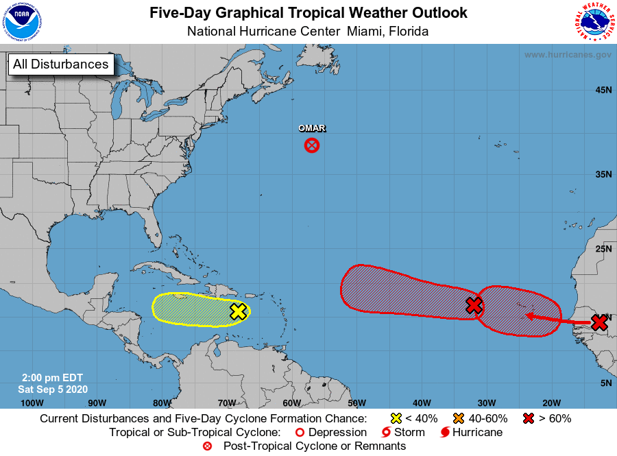
Depression Omar, located about 600 miles northeast of Bermuda.
1. A tropical wave and area of low pressure located over the eastern
tropical Atlantic continues to produce a large area of
disorganized showers and thunderstorms. Gradual development of
this system is expected while it moves westward to
west-northwestward, and a tropical depression is likely to form late
this weekend or early next week when the system reaches the central
tropical Atlantic.
* Formation chance through 48 hours...medium...60 percent.
* Formation chance through 5 days...high...90 percent.
2. A tropical wave located over the east-central Caribbean Sea is
producing an area of showers and thunderstorms. Some slight
development of this system is possible during the next couple of
days before upper-level winds become unfavorable for formation.
This wave is expected to move westward across the central and
western Caribbean Sea during the next few days.
* Formation chance through 48 hours...low...10 percent.
* Formation chance through 5 days...low...10 percent.
3. Another tropical wave located inland over western Africa is
forecast to move offshore on Sunday. Gradual development of this
system is then expected, and a tropical depression is likely to
form by the middle of next week while it moves generally westward
over the far eastern tropical Atlantic.
* Formation chance through 48 hours...low...20 percent.
* Formation chance through 5 days...high...80 percent.
Forecaster Cangialosi