ZCZC MIATWOAT ALL
TTAA00 KNHC DDHHMM
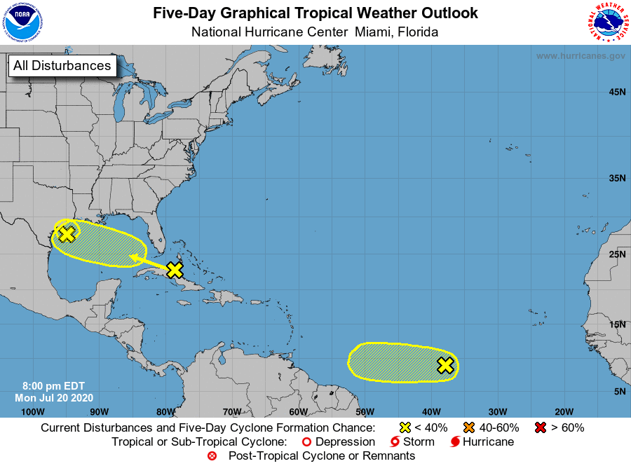
Tropical Weather Outlook
NWS National Hurricane Center Miami FL
800 PM EDT Mon Jul 20 2020
For the North Atlantic...Caribbean Sea and the Gulf of Mexico:
1. A tropical wave is producing a large area of disorganized showers
and thunderstorms over much of Cuba, the central and northwestern
Bahamas, southern Florida, and the adjacent waters. Gradual
development of this system is possible while it moves
west-northwestward during the next few days. This system is
expected to be over the southeastern Gulf of Mexico on Tuesday, the
central Gulf on Wednesday, and the northwestern Gulf on Thursday and
Friday. An Air Force Reserve Hurricane Hunter aircraft is scheduled
to investigate the system tomorrow, if necessary.
* Formation chance through 48 hours...low...20 percent.
* Formation chance through 5 days...low...30 percent.
2. Shower activity has changed little in association with a weak area
of low pressure, and its associated tropical wave, located roughly
midway between the west coast of Africa and the Lesser Antilles.
Environmental conditions are expected to be marginally conducive
for development of this system during the next couple of days while
it moves westward at 10 to 15 mph over the tropical Atlantic. Late
this week, however, less favorable conditions should limit
additional development.
* Formation chance through 48 hours...low...20 percent.
* Formation chance through 5 days...low...20 percent.
3. A weak area of low pressure located over the northwestern Gulf of
Mexico is producing disorganized showers and thunderstorms.
Development of this system appears unlikely before it moves inland
over Texas later tonight or early Tuesday. Regardless of
development, locally heavy rainfall is expected over portions of
southeastern Texas and southern Louisiana during the next day or
two. These rains could result in localized flash flooding.
* Formation chance through 48 hours...low...10 percent.
* Formation chance through 5 days...low...10 percent.
Forecaster Cangialosi