ZCZC MIATWOAT ALL
TTAA00 KNHC DDHHMM
Tropical Weather Outlook
NWS National Hurricane Center Miami FL
200 AM EDT Sat Sep 22 2018
For the North Atlantic...Caribbean Sea and the Gulf of Mexico:
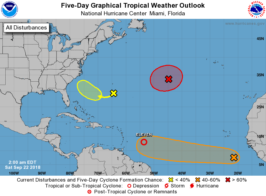
The National Hurricane Center is issuing advisories on newly formed
Tropical Depression Eleven, located about 500 miles east of the
Windward Islands.
1. Showers and thunderstorms have been increasing since last evening
near the center of a low pressure system located about 550 miles
south-southeast of the Cabo Verde Islands. Environmental
conditions appear conducive for further development of this system,
and a tropical depression could form during the next day or two
while the low moves westward across the tropical Atlantic Ocean at
about 20 mph.
* Formation chance through 48 hours...medium...50 percent.
* Formation chance through 5 days...medium...60 percent.
2. A broad area of low pressure located about 200 miles south of
Bermuda is producing minimal shower activity. Strong upper-level
winds are expected to diminish by late this weekend or early next
week, possibly allowing for some slow development of this system
while it moves westward and then northwestward over the
southwestern Atlantic Ocean. By the middle of next week,
upper-level winds are likely to strengthen again, which would limit
development as the system moves closer to the southeastern coast of
the United States.
* Formation chance through 48 hours...low...10 percent.
* Formation chance through 5 days...low...30 percent.
3. A non-tropical low pressure system is forming along a frontal
boundary about 850 miles west-southwest of the Azores. Conditions
are expected to be conducive for the low to acquire subtropical or
tropical characteristics, and a subtropical or tropical cyclone is
likely to form early next week while the low meanders over the
central Atlantic Ocean.
* Formation chance through 48 hours...medium...40 percent.
* Formation chance through 5 days...high...70 percent.
Public Advisories on Tropical Depression Eleven are issued under WMO
header WTNT31 KNHC and under AWIPS header MIATCPAT1.
Forecast/Advisories on Tropical Depression Eleven are issued under
WMO header WTNT21 KNHC and under AWIPS header MIATCMAT1.
Forecaster Berg