ZCZC MIATWOAT ALL
TTAA00 KNHC DDHHMM
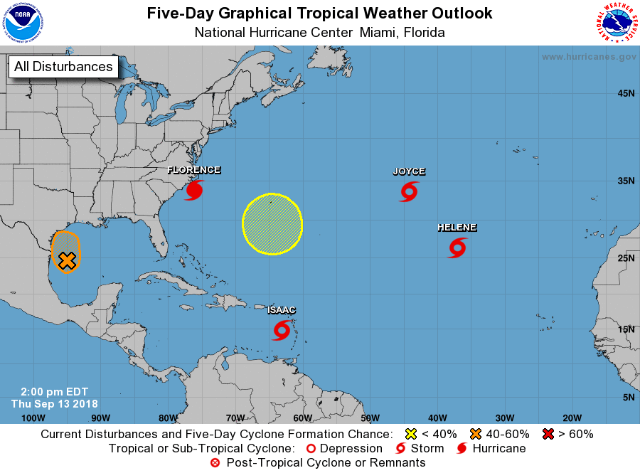
Tropical Weather Outlook
NWS National Hurricane Center Miami FL
200 PM EDT Thu Sep 13 2018
For the North Atlantic...Caribbean Sea and the Gulf of Mexico:
The National Hurricane Center is issuing advisories on Hurricane
Florence, approaching the North Carolina coast, on newly downgraded
Tropical Storm Helene, located over the eastern Atlantic Ocean, on
Tropical Storm Isaac, located near the Lesser Antilles, and on
Subtropical Storm Joyce, located about 1000 miles west-southwest
of the Azores.
1. A weak low pressure center has formed a couple of hundred miles
east-southeast of Brownsville, Texas. In addition, showers and
thunderstorms in association with this system have become more
numerous today. While upper-level winds are generally conducive for
development of a tropical depression, the system only has about a
day before it reaches the western Gulf coast. An Air Force Reserve
Hurricane Hunter aircraft is currently en route to investigate the
low. Regardless of development, heavy rainfall and gusty winds are
expected across portions of northeastern Mexico and Texas on Friday
and Saturday. Interests there should monitor the progress of this
system, and refer to products from their local weather office.
* Formation chance through 48 hours...medium...50 percent.
* Formation chance through 5 days...medium...50 percent.
2. An area of low pressure is expected to develop near Bermuda late
this weekend or early next week. Some gradual development is
possible after that time while the system drifts westward over the
western Atlantic.
* Formation chance through 48 hours...low...near 0 percent.
* Formation chance through 5 days...low...20 percent.
Public Advisories on Subtropical Storm Joyce are issued under WMO
header WTNT35 KNHC and under AWIPS header MIATCPAT5.
Forecast/Advisories on Subtropical Storm Joyce are issued under WMO
header WTNT25 KNHC and under AWIPS header MIATCMAT5.
Forecaster Landsea