


NHC Graphical Outlook Archive
|
« Earliest Available ‹ Earlier Later › Latest Available » |
| Eastern Pacific | Atlantic |
|
|
(mouse over shaded areas for details; click on shaded areas or disturbance numbers to switch views) |
Tropical Weather Outlook Text
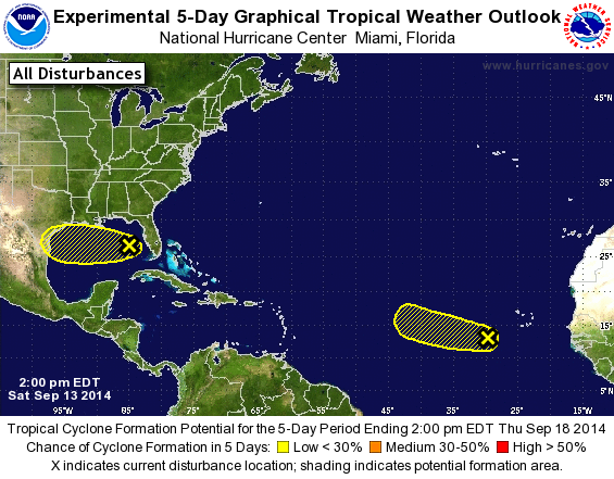
TROPICAL WEATHER OUTLOOK
NWS NATIONAL HURRICANE CENTER MIAMI FL
200 PM EDT SAT SEP 13 2014

For the North Atlantic...Caribbean Sea and the Gulf of Mexico:

The National Hurricane Center is issuing advisories on Tropical
Storm Edouard, located about 1000 miles east-northeast of the
northern Leeward Islands.

1. The area of low pressure over the southeastern Gulf of Mexico is
becoming less defined and the associated shower activity is
decreasing. Upper-level winds are not conducive for development and
the low will most likely degenerate into a trough of low pressure
while it moves westward across the Gulf of Mexico.
* Formation chance through 48 hours...low...10 percent.
* Formation chance through 5 days...low...10 percent.

2. Shower activity associated with a tropical wave located southwest of
the Cape Verde Islands has diminished and development of this system
is not likely to occur as it moves westward or west-northwestward at
around 10 mph.
* Formation chance through 48 hours...low...10 percent.
* Formation chance through 5 days...low...10 percent.

Forecaster Avila
List of Atlantic Outlooks (May 2023 - present)
List of East Pacific Outlooks (May 2023 - present)
List of Central Pacific Outlooks (May 2023 - present)
List of Atlantic Outlooks (July 2014 - April 2023)
List of East Pacific Outlooks (July 2014 - April 2023)
List of Central Pacific Outlooks (June 2019 - April 2023)
List of Atlantic Outlooks (June 2009 - June 2014)
List of East Pacific Outlooks (June 2009 - June 2014)