ZCZC MIATWOEP ALL
TTAA00 KNHC DDHHMM
Tropical Weather Outlook
NWS National Hurricane Center Miami FL
1100 PM PDT Sat Jul 8 2023
For the eastern North Pacific...east of 140 degrees west longitude:
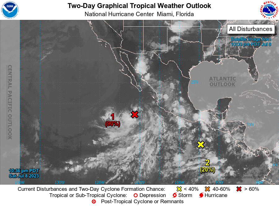
1. Offshore of Southwestern Mexico (EP93):
Showers and thunderstorms continue in association with a large area
of low pressure located several hundred miles west-southwest of
Manzanillo, Mexico. This system has not significantly changed in
organization during the past several hours. However, any increase
in organization would lead to the development of a tropical
depression later today. By tonight and Monday, the system is
expected to move west-northwestward into a less favorable
environment well west of the coast of mainland Mexico. Additional
information on this system, including gale warnings, can be found
in High Seas Forecasts issued by the National Weather Service.
* Formation chance through 48 hours...high...90 percent.
* Formation chance through 7 days...high...90 percent.
2. Offshore of Southern Mexico:
A trough of low pressure a few hundred miles south of southern
Mexico is producing disorganized showers and thunderstorms.
Environmental conditions are expected to be conducive for gradual
development during the next several days, and a tropical depression
is likely to form during the early to middle portions of next week.
The system is expected to move westward to west-northwestward,
remaining well offshore of the coast of southern and southwestern
Mexico.
* Formation chance through 48 hours...low...20 percent.
* Formation chance through 7 days...high...80 percent.
High Seas Forecasts issued by the National Weather Service
can be found under AWIPS header NFDHSFEPI, WMO header FZPN02
KWBC, and on the web at ocean.weather.gov/shtml/NFDHSFEPI.php
Forecaster Beven