ZCZC MIATWOAT ALL
TTAA00 KNHC DDHHMM
Tropical Weather Outlook
NWS National Hurricane Center Miami FL
200 AM EDT Tue Oct 10 2023
For the North Atlantic...Caribbean Sea and the Gulf of Mexico:
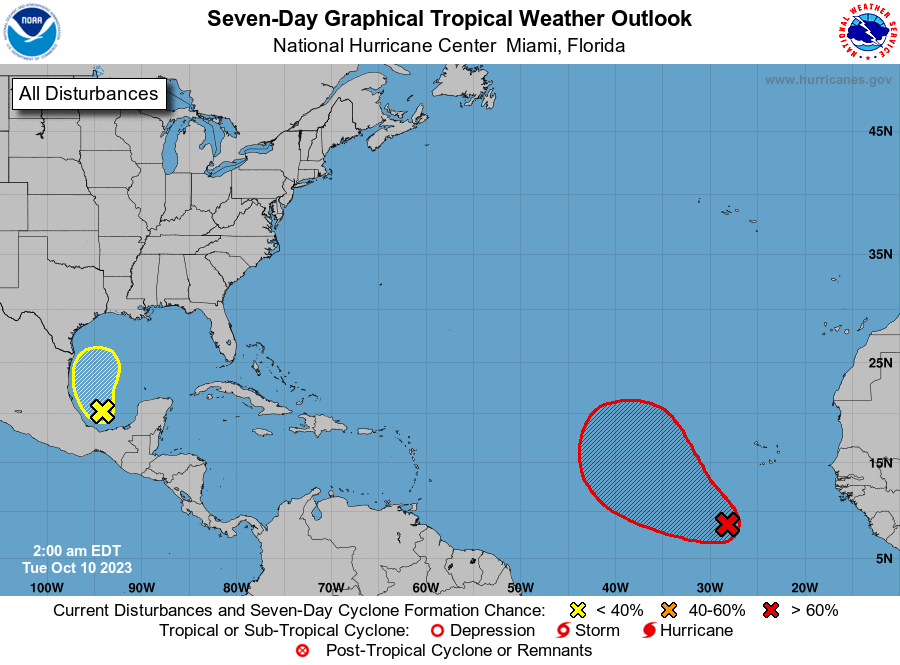
1. Eastern Tropical Atlantic (AL92):
A broad area of low pressure located several hundred miles
southwest of the Cabo Verde Islands continues to produce a large
area of showers and thunderstorms. This activity has changed
little in organization since yesterday. However, environmental
conditions appear conducive for gradual development, and a tropical
depression is likely to form during the next couple of days while
the system moves west-northwestward or northwestward across the
eastern tropical Atlantic.
* Formation chance through 48 hours...high...70 percent.
* Formation chance through 7 days...high...80 percent.
2. Southwestern Gulf of Mexico (AL93):
A small low pressure system over the southwestern Gulf of Mexico
continues to produce an area of disorganized cloudiness and
thunderstorms. Environmental conditions appear only marginally
favorable for some additional development while the system moves
slowly northward during the next day or so. The low is forecast to
merge with a frontal system over the western Gulf of Mexico by
Wednesday morning. Regardless of tropical cyclone development, the
system is forecast to produce gale-force winds over portions of
the northern Gulf of Mexico by Wednesday. Additional information
on this system, including gale warnings, can be found in High Seas
Forecasts issued by the National Weather Service.
* Formation chance through 48 hours...low...20 percent.
* Formation chance through 7 days...low...20 percent.
High Seas Forecasts issued by the National Weather Service
can be found under AWIPS header NFDHSFAT1, WMO header FZNT01
KWBC, and online at ocean.weather.gov/shtml/NFDHSFAT1.php
Forecaster Blake