ZCZC MIATWOAT ALL
TTAA00 KNHC DDHHMM
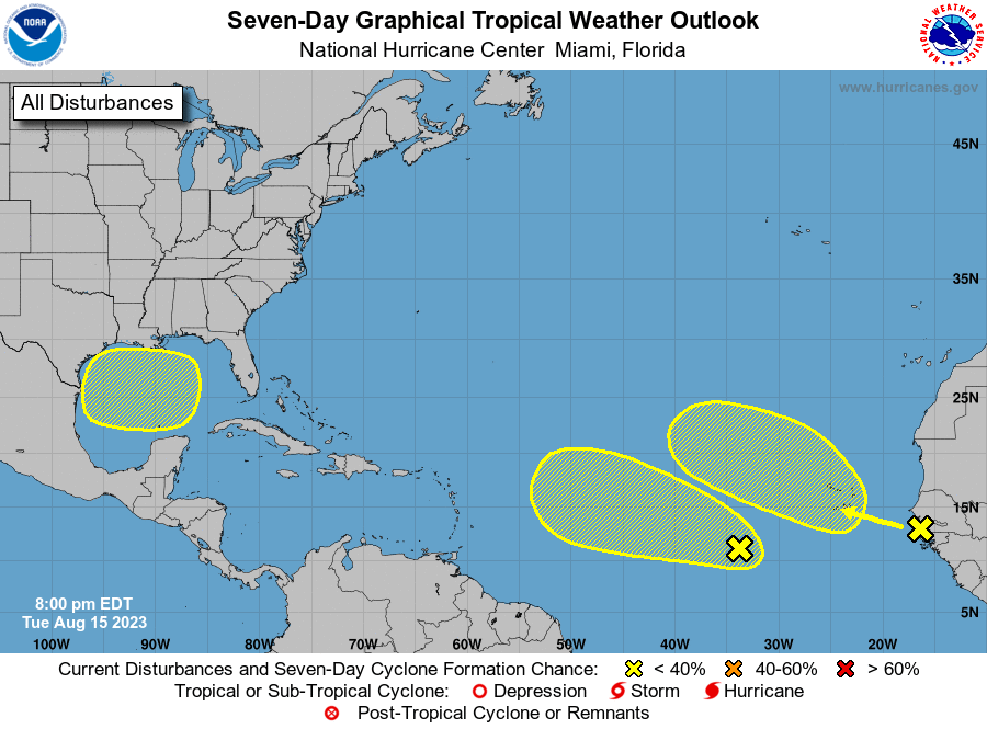
Tropical Weather Outlook
NWS National Hurricane Center Miami FL
800 PM EDT Tue Aug 15 2023
For the North Atlantic...Caribbean Sea and the Gulf of Mexico:
1. Central Tropical Atlantic:
A tropical wave, interacting with a larger trough of low pressure,
continues to produce disorganized showers and thunderstorms a few
hundred miles west-southwest of the Cabo Verde Islands.
Environmental conditions appear to be conducive for some gradual
development of this system during the next several days as it moves
to the west-northwestward or northwestward between 10-15 mph across
the tropical Atlantic through the weekend.
* Formation chance through 48 hours...low...10 percent.
* Formation chance through 7 days...low...30 percent.
2. Eastern Tropical Atlantic:
A tropical wave currently along the western coast of Africa is
producing a large area of showers and thunderstorms. Some slow
development of this system is possible later this week and into the
weekend while it moves generally west-northwestward or northwestward
across the eastern Atlantic. Environmental conditions are expected
to become more unfavorable for development by early next week.
* Formation chance through 48 hours...low...near 0 percent.
* Formation chance through 7 days...low...30 percent.
3. Western Gulf of Mexico:
A broad area of low pressure could form in the central or western
Gulf of Mexico by the beginning of next week. Some slow development
of this system is possible thereafter as it moves generally
westward, potentially nearing the western Gulf of Mexico coastline
in about a week.
* Formation chance through 48 hours...low...near 0 percent.
* Formation chance through 7 days...low...20 percent.
Forecaster Papin