ZCZC MIATWOAT ALL
TTAA00 KNHC DDHHMM
Tropical Weather Outlook
NWS National Hurricane Center Miami FL
800 PM EDT Sat Oct 1 2022
For the North Atlantic...Caribbean Sea and the Gulf of Mexico:
Active Systems:
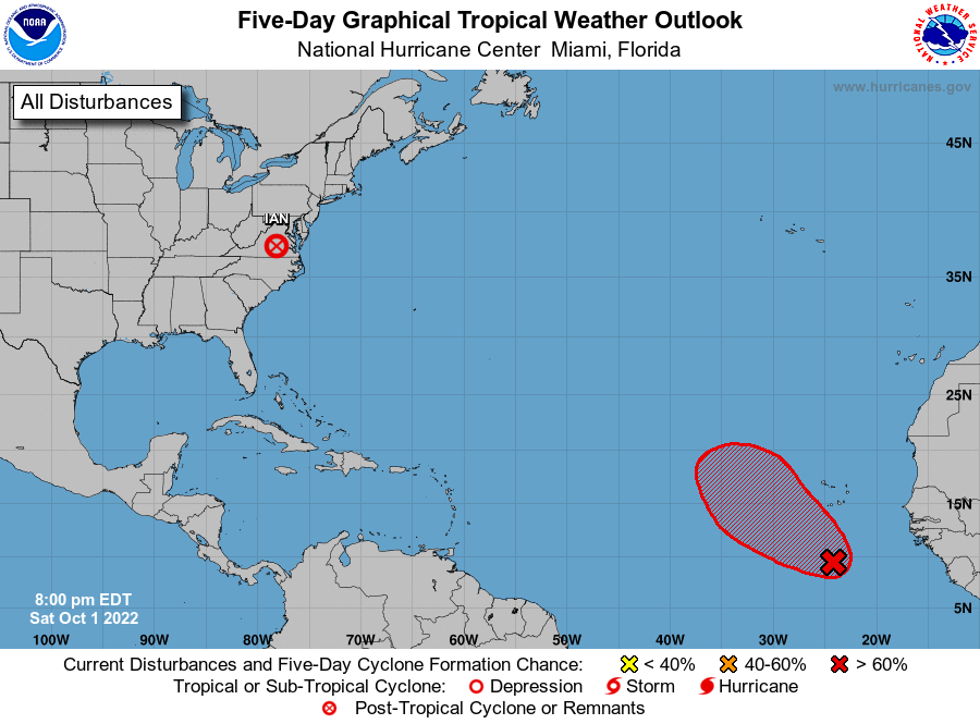
The Weather Prediction Center is issuing advisories on Post-Tropical
Cyclone Ian, located over southern Virginia.
1. Eastern Tropical Atlantic:
Disorganized shower and thunderstorm activity located several
hundred miles south of the Cabo Verde Islands is associated with a
tropical wave. Although the organization of this system has not
improved since yesterday, environmental conditions are forecast to
be favorable for some gradual development during the next several
days. A tropical depression is likely to form during the early or
middle part of next week while the system moves westward, then turns
northwestward or northward over the eastern tropical Atlantic.
* Formation chance through 48 hours...low...20 percent.
* Formation chance through 5 days...high...70 percent.
Advisories issued by the Weather Prediction Center on Post-Tropical
Cyclone Ian can be found under AWIPS header TCPAT4, WMO header
WTNT34 KWNH, in addition to on the web at
http://www.wpc.ncep.noaa.gov and http://www.nhc.noaa.gov
Forecaster Reinhart