ZCZC MIATWOAT ALL
TTAA00 KNHC DDHHMM
Tropical Weather Outlook
NWS National Hurricane Center Miami FL
200 PM EDT Thu Sep 22 2022
For the North Atlantic...Caribbean Sea and the Gulf of Mexico:
Active Systems:
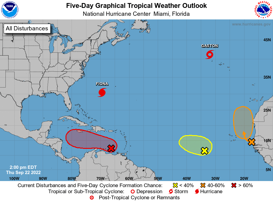
The National Hurricane Center is issuing advisories on Hurricane
Fiona, located a few hundred miles southwest of Bermuda,
and on Tropical Storm Gaston, located a few hundred miles
west-northwest of the central Azores.
1. Southeastern Caribbean Sea:
Satellite wind data and surface observations indicate that an area
of low pressure has formed in the southeastern Caribbean Sea, though
the associated shower and thunderstorm activity remains
disorganized. The environment is forecast to become more conducive
for development, and a tropical depression is likely to form in the
next day or so. The low is forecast to move west-northwestward and
be over the central Caribbean Sea this weekend where conditions are
expected to be conducive for additional development. Locally heavy
rainfall and gusty winds are likely to affect the Windward Islands,
northern Venezuela, and the ABC island chain today. These impacts
are likely to spread to northeastern Colombia later this evening.
Interests in Jamaica should closely monitor the progress of this
system.
* Formation chance through 48 hours...high...80 percent.
* Formation chance through 5 days...high...90 percent.
2. Eastern Tropical Atlantic:
Showers and thunderstorms located near the west coast of Africa are
associated with a tropical wave that has emerged over the warm
waters of the far eastern Atlantic. Environmental conditions are
forecast to be conducive for some development, and a tropical
depression could form by this weekend while the system moves slowly
northward, between west Africa and the Cabo Verde Islands.
* Formation chance through 48 hours...medium...60 percent.
* Formation chance through 5 days...medium...60 percent.
3. East Central Tropical Atlantic:
A broad area of low pressure located several hundred miles
west-southwest of the Cabo Verde Islands continues to produce
disorganized showers and thunderstorms. Despite marginal
environmental conditions, some slow development of this system is
possible over the next several days while it moves slowly
northwestward or northward over the tropical Atlantic.
* Formation chance through 48 hours...low...20 percent.
* Formation chance through 5 days...low...30 percent.
Forecaster Bucci