ZCZC MIATWOAT ALL
TTAA00 KNHC DDHHMM
Tropical Weather Outlook
NWS National Hurricane Center Miami FL
800 PM EDT Thu Sep 8 2022
For the North Atlantic...Caribbean Sea and the Gulf of Mexico:
Active Systems:
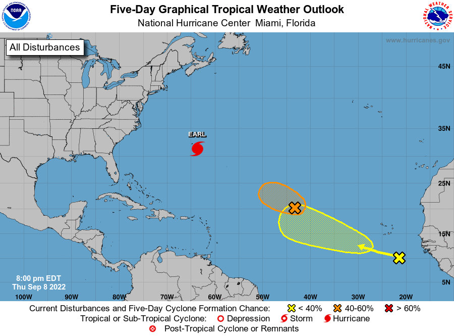
The National Hurricane Center is issuing advisories on Hurricane
Earl, located less than 140 miles south of Bermuda.
1. Central Tropical Atlantic:
A low pressure system located about 1300 miles east of the northern
Leeward Islands is producing shower and thunderstorm activity that
is displaced well to the northeast of the circulation center by
strong upper-level winds. Environmental conditions appear to be only
marginally conducive for additional development. However, an
increase in organization of the system could still result in the
formation of a short-lived tropical cyclone in the next day or so as
it moves westward to west-northwestward at 15 to 20 mph over the
central tropical Atlantic. By this weekend, environmental
conditions are forecast to become less conducive for development.
For more information on this system, including Gale Warnings, please
refer to the High Seas Forecasts issued by the National Weather
Service.
* Formation chance through 48 hours...medium...60 percent.
* Formation chance through 5 days...medium...60 percent.
2. Eastern Tropical Atlantic:
A tropical wave located several hundred miles south-southeast of
the Cabo Verde Islands is producing a disorganized area of showers
and thunderstorms. Environmental conditions appear conducive for
some gradual development during the next several days while the
system moves generally west-northwestward over the eastern tropical
Atlantic.
* Formation chance through 48 hours...low...near 0 percent.
* Formation chance through 5 days...low...30 percent.
High Seas Forecasts issued by the National Weather Service
can be found under AWIPS header NFDHSFAT1, WMO header FZNT01
KWBC, and online at ocean.weather.gov/shtml/NFDHSFAT1.php
Forecaster Bucci/Pasch