ZCZC MIATWOAT ALL
TTAA00 KNHC DDHHMM
Special Tropical Weather Outlook
NWS National Hurricane Center Miami FL
605 PM EDT Fri Sep 2 2022
For the North Atlantic...Caribbean Sea and the Gulf of Mexico:
Special Tropical Weather Outlook issued to update the discussion of
the low pressure system located east of the Leeward Islands.
Active Systems:
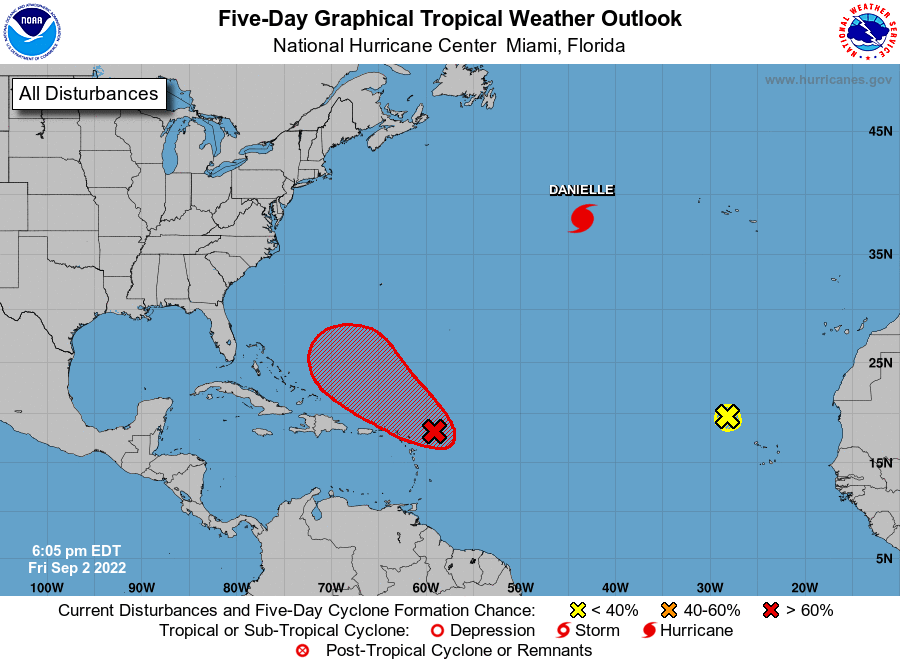
The National Hurricane Center is issuing advisories on Hurricane
Danielle, located about 900 miles west of the Azores.
1. East of the Leeward Islands:
Updated: Data from an Air Force Reserve Hurricane Hunter aircraft
indicate that the circulation associated with an area of low
pressure located a couple of hundred miles east of the Leeward
Islands has become better defined today, and the plane reported that
surface pressures have fallen a bit. If the showers and
thunderstorms associated with the low persist through the evening,
the system could become a tropical depression as early as tonight.
The disturbance is expected to move slowly west-northwestward,
toward the adjacent waters of the northern Leeward Islands.
Regardless of development, locally heavy rains may occur over
portions of the Leeward Islands during the next couple of days, and
interests in that area should monitor the progress of the system.
Additional information on this system can be found in High Seas
Forecasts issued by the National Weather Service.
* Formation chance through 48 hours...high...70 percent.
* Formation chance through 5 days...high...70 percent.
2. Eastern Tropical Atlantic:
Shower activity associated with a broad area of low pressure located
northwest of the Cabo Verde Islands has diminished. Significant
development is not expected as this system moves generally
west-northwestward into an area of unfavorable environmental
conditions.
* Formation chance through 48 hours...low...near 0 percent.
* Formation chance through 5 days...low...near 0 percent.
High Seas Forecasts issued by the National Weather Service can be
found under AWIPS header NFDHSFAT1, WMO header FZNT01 KWBC, and
online at ocean.weather.gov/shtml/NFDHSFAT1.php
Forecaster Berg