ZCZC MIATWOAT ALL
TTAA00 KNHC DDHHMM
Tropical Weather Outlook
NWS National Hurricane Center Miami FL
800 AM EDT Thu Sep 1 2022
For the North Atlantic...Caribbean Sea and the Gulf of Mexico:
Active Systems:
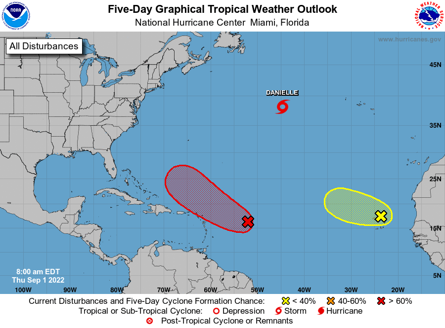
The National Hurricane Center is issuing advisories on newly formed
Tropical Depression Five, located about 1000 miles west of the
Azores.
1. East of the Leeward Islands:
Showers and thunderstorms associated with a broad area of low
pressure located several hundred miles east of the Leeward Islands
have changed little this morning. Although environmental conditions
remain only marginally conducive, any additional development of the
system over the next few days would lead to the formation of a
tropical depression. The disturbance is forecast to move slowly
west-northwestward, toward the adjacent waters of the northern
Leeward Islands. Additional information on this system can be found
in High Seas Forecasts issued by the National Weather Service.
* Formation chance through 48 hours...medium...60 percent.
* Formation chance through 5 days...high...80 percent.
2. Eastern Tropical Atlantic:
Satellite imagery and surface observations show that a broad area
of low pressure is located over and to the northwest of the Cabo
Verde Islands. While surface observations indicate pressures are
low in this area, the associated shower activity is currently
poorly organized. There is still some chance for the system to
become a short-lived tropical depression within the next day or so
before environmental conditions become unfavorable for further
development. Regardless, the system could bring locally heavy
rainfall to portions of the Cabo Verde Islands today and tonight.
* Formation chance through 48 hours...low...30 percent.
* Formation chance through 5 days...low...30 percent.
Public Advisories on Tropical Depression Five are issued
under WMO header WTNT35 KNHC and under AWIPS header MIATCPAT4.
Forecast/Advisories on Tropical Depression Five are issued
under WMO header WTNT25 KNHC and under AWIPS header MIATCMAT4.
High Seas Forecasts issued by the National Weather Service
can be found under AWIPS header NFDHSFAT1, WMO header FZNT01
KWBC, and online at ocean.weather.gov/shtml/NFDHSFAT1.php
Forecaster Bucci/Cangialosi