ZCZC MIATWOAT ALL
TTAA00 KNHC DDHHMM
Tropical Weather Outlook
NWS National Hurricane Center Miami FL
200 AM EDT Sun Aug 28 2022
For the North Atlantic...Caribbean Sea and the Gulf of Mexico:
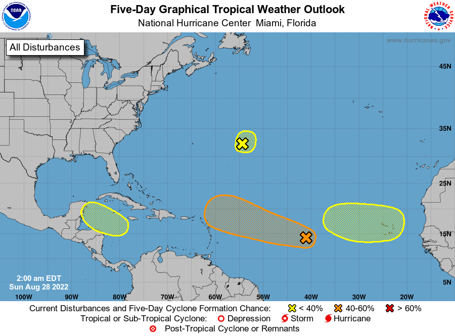
1. Central Tropical Atlantic:
A broad and elongated area of low pressure over the central
tropical Atlantic is producing disorganized showers and
thunderstorms. Environmental conditions are expected to be
generally conducive for gradual development, and a tropical
depression could form by the middle of the week while it moves
west-northwestward at 10 to 15 mph toward the waters east of the
Leeward Islands.
* Formation chance through 48 hours...low...20 percent.
* Formation chance through 5 days...medium...60 percent.
2. Central Atlantic:
Shower activity has become less organized during the past several
hours in association with a small low pressure system located
about 600 miles east of Bermuda. Some slow development of this
system is possible during the next couple of days while the low
meanders over the central Atlantic. After that time, environmental
conditions are expected to become unfavorable for development.
* Formation chance through 48 hours...low...10 percent.
* Formation chance through 5 days...low...20 percent.
3. Northwestern Caribbean Sea:
A trough of low pressure could develop over the northwestern
Caribbean Sea during the early or middle part of the week.
Environmental conditions could support some slow development of the
system thereafter while it moves generally west-northwestward over
the northwestern Caribbean Sea and toward the Yucatan Peninsula of
Mexico.
* Formation chance through 48 hours...low...near 0 percent.
* Formation chance through 5 days...low...20 percent.
4. Eastern Tropical Atlantic:
A tropical wave is forecast to move off the west coast of Africa in
a couple of days. Some gradual development of the system is possible
after that time while it moves generally westward across the far
eastern tropical Atlantic.
* Formation chance through 48 hours...low...near 0 percent.
* Formation chance through 5 days...low...20 percent.
Forecaster Cangialosi