ZCZC MIATWOEP ALL
TTAA00 KNHC DDHHMM
Tropical Weather Outlook
NWS National Hurricane Center Miami FL
500 PM PDT Tue Aug 2 2022
For the eastern North Pacific...east of 140 degrees west longitude:
Active Systems:
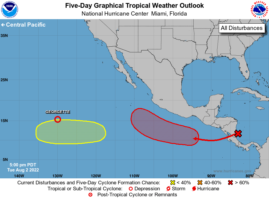
The National Hurricane Center has issued the last advisory on
Post-Tropical Cyclone Frank, located about 700 miles southwest
of San Diego, California, and is issuing advisories on Tropical
Depression Georgette, located about 1400 miles west-southwest of
the southern tip of the Baja California peninsula.
1. Offshore of Southern Mexico:
A tropical wave is producing a large area of disorganized showers
and thunderstorms over Central America and the adjacent waters. The
wave is expected to move over the eastern Pacific waters on
Wednesday, and an area of low pressure is forecast to form a few
hundred miles south of southern Mexico in a couple of days.
Environmental conditions are expected to be favorable for gradual
development thereafter, and a tropical depression is likely to form
by this weekend and move west-northwestward, remaining well
offshore of the coast of southern Mexico.
* Formation chance through 48 hours...low...20 percent.
* Formation chance through 5 days...high...70 percent.
2. Well Southwest of Southwestern Mexico:
Another area of low pressure could form several hundred miles
south-southwest of the southern tip of the Baja California peninsula
later this week. Some gradual development of this system is
possible by the end of this week while it moves westward over the
open waters of the eastern Pacific basin.
* Formation chance through 48 hours...low...near 0 percent.
* Formation chance through 5 days...low...20 percent.
Forecaster Berg/Bucci