ZCZC MIATWOEP ALL
TTAA00 KNHC DDHHMM
Tropical Weather Outlook
NWS National Hurricane Center Miami FL
500 PM PDT Mon Jul 25 2022
For the eastern North Pacific...east of 140 degrees west longitude:
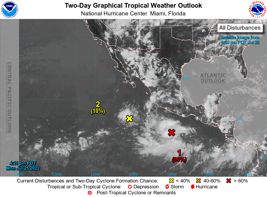
1. Offshore of Southern Mexico:
Shower and thunderstorm activity is gradually becoming better
organized in association with an area of low pressure located a few
hundred miles south of the coast of southern Mexico. Environmental
conditions appear conducive for additional development, and this
system is expected to become a tropical depression later tonight
or on Tuesday. The system is forecast to move generally
westward at 10 to 15 mph, remaining well south of the coast of
southern and southwestern Mexico during the next several days.
* Formation chance through 48 hours...high...90 percent.
* Formation chance through 5 days...high...90 percent.
2. South of Baja California peninsula:
Shower and thunderstorm activity has persisted with a small area of
low pressure located several hundred miles south of the southern
tip of the Baja California peninsula. Some slight development with
this system is possible over the next day or two while it moves
little.
* Formation chance through 48 hours...low...10 percent.
* Formation chance through 5 days...low...10 percent.
Forecaster Bucci/Cangialosi