ZCZC MIATWOAT ALL
TTAA00 KNHC DDHHMM
Tropical Weather Outlook
NWS National Hurricane Center Miami FL
200 AM EDT Tue Jun 28 2022
For the North Atlantic...Caribbean Sea and the Gulf of Mexico:
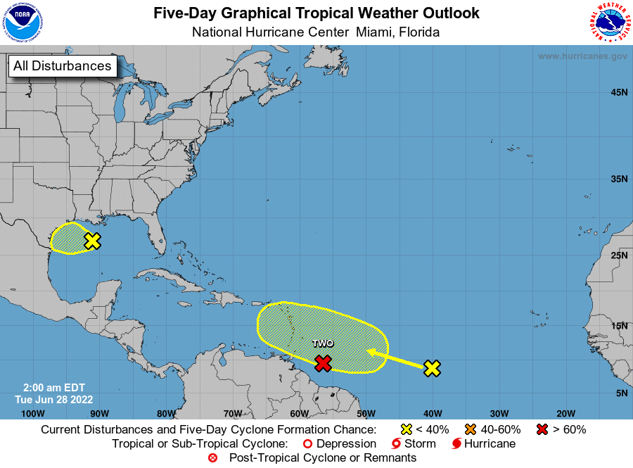
East of the Windward Islands:
The National Hurricane Center is issuing advisories on Potential
Tropical Cyclone Two, located several hundred miles east of the
southern Windward Islands.
* Formation chance through 48 hours...high...70 percent.
* Formation chance through 5 days...high...90 percent.
1. Northern Gulf of Mexico:
A surface trough of low pressure is located over the north-central
Gulf of Mexico. While shower and thunderstorm activity with this
system is currently limited, surface pressures have fallen
some over the last 24 hours. Some additional development of this
system is possible as it moves generally westward at 5-10 mph and
approaches the coast of Texas during the next few days.
* Formation chance through 48 hours...low...20 percent.
* Formation chance through 5 days...low...30 percent.
2. Central Tropical Atlantic:
A tropical wave located about 1200 miles east of the Windward
Islands is producing disorganized showers and thunderstorms. This
system is forecast to interact with another tropical wave to its
east over the next several days, and some gradual development is
possible later this week while the overall system moves west-
northwestward at around 15 mph across the central tropical Atlantic.
* Formation chance through 48 hours...low...near 0 percent.
* Formation chance through 5 days...low...20 percent.
Public Advisories on Potential Tropical Cyclone Two are issued
under WMO header WTNT32 KNHC and under AWIPS header MIATCPAT2.
Forecast/Advisories on Potential Tropical Cyclone Two are issued
under WMO header WTNT22 KNHC and under AWIPS header MIATCMAT2.
Forecaster Papin