ZCZC MIATWOAT ALL
TTAA00 KNHC DDHHMM
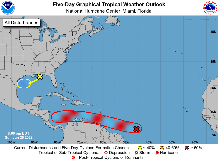
Tropical Weather Outlook
NWS National Hurricane Center Miami FL
800 PM EDT Sun Jun 26 2022
For the North Atlantic...Caribbean Sea and the Gulf of Mexico:
1. Central Tropical Atlantic:
Shower and thunderstorm activity associated with a tropical wave
located about 1000 miles east-southeast of the southern Windward
Islands has changed little in organization since earlier today.
However, environmental conditions appear conducive for development,
and a tropical depression is likely to form during the next few days
before the system reaches the Windward Islands Tuesday night or
while moving westward across the southern Caribbean Sea Wednesday
through Friday. Interests in the Windward Islands and along the
northeastern coast of Venezuela should monitor the progress of this
system, and tropical storm watches or warnings could be required for
portions of these areas on Monday. Regardless of development,
locally heavy rainfall is possible over the Windward Islands and the
northeastern coast of Venezuela Tuesday night and Wednesday.
* Formation chance through 48 hours...medium...60 percent.
* Formation chance through 5 days...high...80 percent.
2. Northern Gulf of Mexico:
Disorganized showers and thunderstorms over the north-central and
northeastern Gulf of Mexico are associated with a trough of low
pressure. Development of this system is expected to be slow to
occur while it moves west-southwestward at about 10 mph toward the
northwestern Gulf of Mexico and approaches the coasts of southern
Texas and northeastern Mexico during the next few days.
* Formation chance through 48 hours...low...10 percent.
* Formation chance through 5 days...low...20 percent.
Forecaster Berg