ZCZC MIATWOAT ALL
TTAA00 KNHC DDHHMM
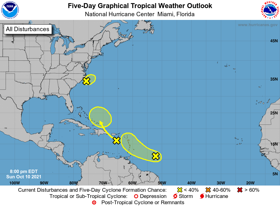
Tropical Weather Outlook
NWS National Hurricane Center Miami FL
800 PM EDT Sun Oct 10 2021
For the North Atlantic...Caribbean Sea and the Gulf of Mexico:
1. A non-tropical low pressure area located about 75 miles south of
Cape Hatteras, North Carolina, continues to produce disorganized
showers and a few thunderstorms. Recent radar and satellite imagery
indicates that the circulation of the low has become less defined
since this morning. Dry air and strong upper-level winds are
expected to prevent any further development of this system while
it moves slowly northward or north-northeastward through Monday.
Regardless of development, locally heavy rainfall and gusty winds
are still possible over portions of the North Caroling Outer Banks
through Monday and information on these hazards can be found in
products issued by your local National Weather Service Office.
Additional information on this low pressure system, including gale
warnings, can be found in High Seas Forecasts issued by the National
Weather Service.
* Formation chance through 48 hours...low...10 percent.
* Formation chance through 5 days...low...10 percent.
2. A tropical wave located about a little more than 500 miles east-
southeast of the Windward Islands continues to produce a large area
of disorganized cloudiness and thunderstorms. Environmental
conditions are forecast to be marginally conducive, and some
limited development could occur during the next day or so while the
system moves west-northwestward at about 15 mph. After that time,
strong upper-level winds are expected to limit further development.
The disturbance is forecast to approach the central and northern
Lesser Antilles by late Monday and early Tuesday. Regardless of
development, the system could produce locally heavy rainfall and
gusty winds across portions of the central and northern Lesser
Antilles on Tuesday, and across the Virgin Islands and Leeward
Islands on Wednesday.
* Formation chance through 48 hours...low...20 percent.
* Formation chance through 5 days...low...30 percent.
3. Another tropical wave located over the eastern Caribbean Sea is
producing a large area of disorganized cloudiness and showers over
portions of the Leeward Islands, the Virgin Islands, and Puerto
Rico. Unfavorable upper-level winds are expected to limit any
development over the next day or so, but environmental conditions
could become a little more conducive for some gradual development of
the system when it is located near the southeastern Bahamas around
midweek. Regardless of development, locally heavy rainfall is
possible over portions of the Virgin Islands, Puerto Rico, and
Hispaniola during the next couple of days.
* Formation chance through 48 hours...low...10 percent.
* Formation chance through 5 days...low...20 percent.
High Seas Forecasts issued by the National Weather Service can be
found under AWIPS header NFDHSFAT1, WMO header FZNT01 KWBC, and
online at ocean.weather.gov/shtml/NFDHSFAT1.php
Forecaster Brown