ZCZC MIATWOAT ALL
TTAA00 KNHC DDHHMM
Tropical Weather Outlook
NWS National Hurricane Center Miami FL
200 AM EDT Mon Sep 20 2021
For the North Atlantic...Caribbean Sea and the Gulf of Mexico:
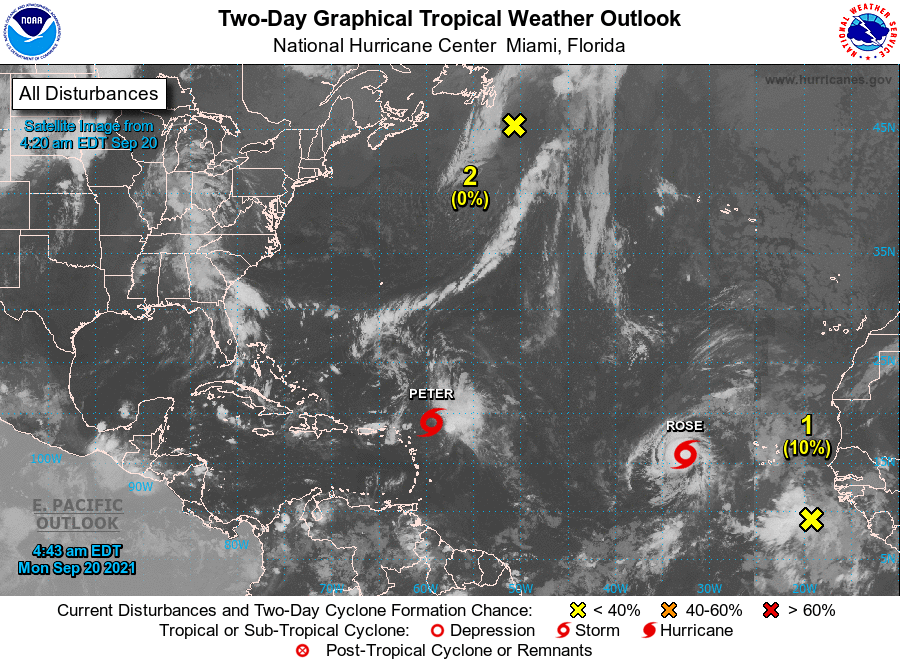
The National Hurricane Center is issuing advisories on Tropical
Storm Peter, located a few hundred miles east of the northernmost
Leeward Islands, and on Tropical Storm Rose, located several hundred
miles west of the southernmost Cabo Verde Islands.
1. A tropical wave located over the far eastern tropical Atlantic
several hundred miles southeast of the Cabo Verde Islands is
producing an area of disorganized showers and thunderstorms.
Environmental conditions appear conducive for gradual development
over the next several days, and a tropical depression could form
later this week while the system moves westward at 10 to 15 mph
across the eastern and central tropical Atlantic Ocean.
* Formation chance through 48 hours...low...10 percent.
* Formation chance through 5 days...medium...60 percent.
2. A storm-force, non-tropical low pressure system, the remnants
of Odette, is located a couple of hundred miles southeast of
Newfoundland. This low could acquire some subtropical
characteristics by the middle of this week as it moves slowly
eastward and then southeastward over warmer waters across the
north-central Atlantic Ocean. Additional information on this
system, including storm warnings, can be found in High Seas
Forecasts issued by the National Weather Service.
* Formation chance through 48 hours...low...near 0 percent.
* Formation chance through 5 days...low...30 percent.
Public Advisories on Tropical Storm Rose are issued under WMO
header WTNT32 KNHC and under AWIPS header MIATCPAT2.
Forecast/Advisories on Tropical Storm Rose are issued under WMO
header WTNT22 KNHC and under AWIPS header MIATCMAT2.
High Seas Forecasts issued by the National Weather Service can be
found under AWIPS header NFDHSFAT1, WMO header FZNT01 KWBC, and
online at ocean.weather.gov/shtml/NFDHSFAT1.php
Forecaster Stewart