ZCZC MIATWOAT ALL
TTAA00 KNHC DDHHMM
Tropical Weather Outlook
NWS National Hurricane Center Miami FL
800 PM EDT Wed Sep 8 2021
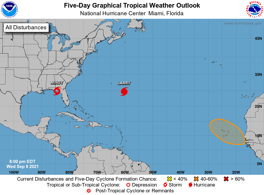
For the North Atlantic...Caribbean Sea and the Gulf of Mexico:
The National Hurricane Center is issuing advisories on Hurricane
Larry, located over the central Atlantic several hundred miles
east-southeast of Bermuda, and on newly developed Tropical Storm
Mindy, located about 25 miles west-southwest of Apalachicola,
Florida.
1. A strong tropical wave is expected to emerge off of the western
coast of Africa in a few days. Additional development of this
system is possible thereafter, and a tropical depression could form
by early next week as it moves west-northwestward over the far
eastern Atlantic near the Cabo Verde Islands.
* Formation chance through 48 hours...low...near 0 percent.
* Formation chance through 5 days...medium...40 percent.
Public Advisories on Tropical Storm Mindy are issued under WMO
header WTNT33 KNHC and under AWIPS header MIATCPAT3.
Forecast/Advisories on Tropical Storm Mindy are issued under WMO
header WTNT23 KNHC and under AWIPS header MIATCMAT3.
Forecaster Papin