ZCZC MIATWOEP ALL
TTAA00 KNHC DDHHMM
Tropical Weather Outlook
NWS National Hurricane Center Miami FL
500 PM PDT Mon Sep 6 2021
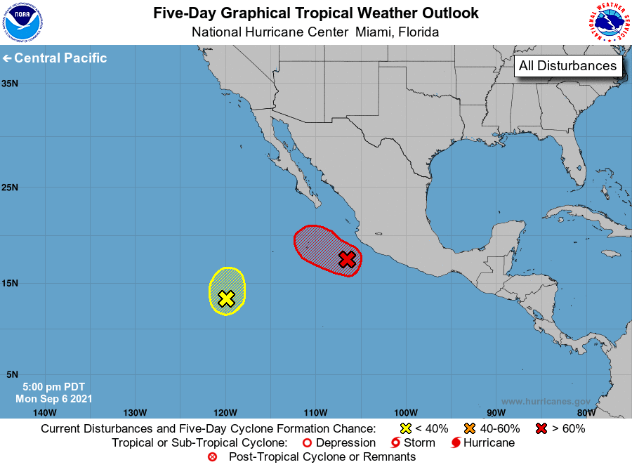
For the eastern North Pacific...east of 140 degrees west longitude:
1. Showers and thunderstorms are gradually becoming better organized in
association with an broad area of low pressure located a couple
hundred miles south-southwest of Manzanillo, Mexico. Environmental
conditions are conducive for additional development of this system,
and a tropical depression is likely to form during the next couple
of days while it moves generally west-northwestward at 5 to 10 mph,
just offshore of the coast of Mexico. However, outer rainbands will
produce locally heavy rainfall and gusty winds along the coast of
the Mexican states of Colima and Jalisco for the next day or so.
* Formation chance through 48 hours...high...90 percent.
* Formation chance through 5 days...high...90 percent.
2. A broad area of low pressure located several hundred miles southwest
of the southern tip of the Baja California peninsula is producing
disorganized showers and thunderstorms. Development, if any, of
this system is likely to be slow over the next couple of days
while it drifts northward. By late this week, environmental
conditions are expected to become unfavorable for further
development.
* Formation chance through 48 hours...low...10 percent.
* Formation chance through 5 days...low...10 percent.
Forecaster Stewart