ZCZC MIATWOAT ALL
TTAA00 KNHC DDHHMM
Tropical Weather Outlook
NWS National Hurricane Center Miami FL
800 PM EDT Thu Sep 2 2021
For the North Atlantic...Caribbean Sea and the Gulf of Mexico:
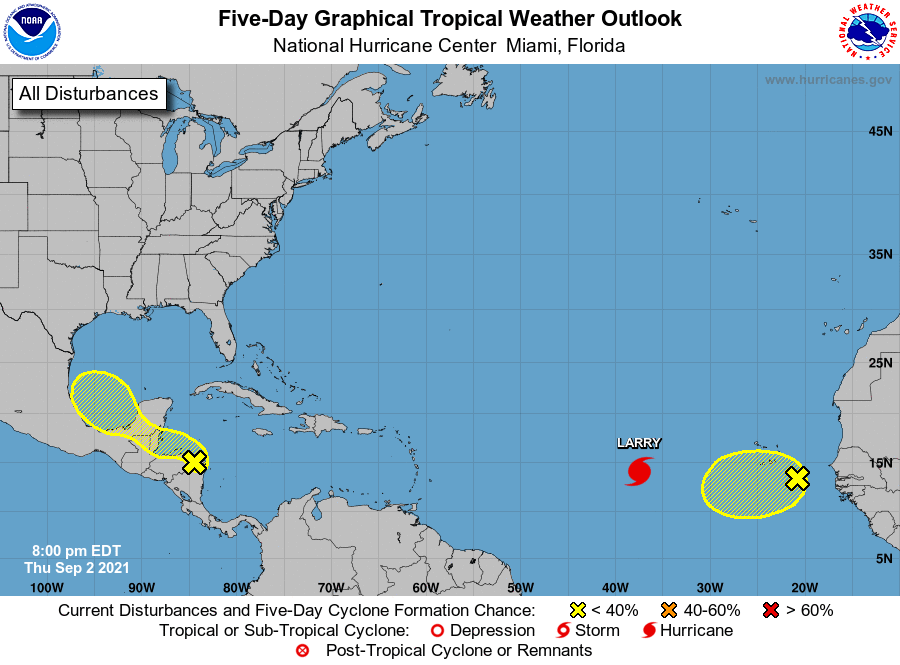
The National Hurricane Center is issuing advisories on Hurricane
Larry, located over the eastern tropical Atlantic several hundred
miles west of the southernmost Cabo Verde Islands.
1. A small area of low pressure and associated surface trough over
eastern Honduras is producing disorganized shower and thunderstorm
activity over portions of the western Caribbean Sea. A portion of
the low's circulation could move over the Gulf of Honduras on
Friday. However, development there, if any, is expected to be slow
to occur. This system could then move over the southwestern Gulf of
Mexico during the weekend, but by then unfavorable upper-level winds
are likely to limit significant development early next week while
the system moves northwestward or northward over the western Gulf
of Mexico. Regardless of development, heavy rains are possible
across portions of Central America and the Yucatan Peninsula through
the weekend.
* Formation chance through 48 hours...low...10 percent.
* Formation chance through 5 days...low...20 percent.
2. Showers and thunderstorms associated with an area of low pressure
located a couple of hundred miles southeast of the southernmost Cabo
Verde Islands continue to show some signs of organization. Some
limited development of this system could occur tonight and on
Friday as the low moves generally westward at 10 to 15 mph. After
that time, conditions are expected to become less conducive for
development. Interests in the Cabo Verde Islands should monitor
the progress of this system.
* Formation chance through 48 hours...low...30 percent.
* Formation chance through 5 days...low...30 percent.
Forecaster Brown