ZCZC MIATWOAT ALL
TTAA00 KNHC DDHHMM
Tropical Weather Outlook
NWS National Hurricane Center Miami FL
200 PM EDT Sun Aug 29 2021
For the North Atlantic...Caribbean Sea and the Gulf of Mexico:
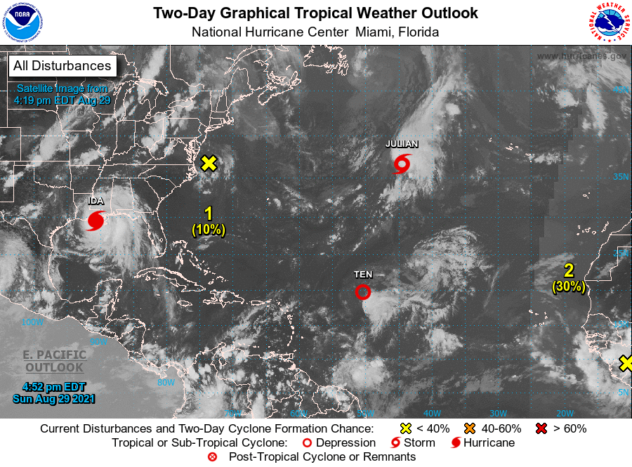
The National Hurricane Center is issuing advisories on Hurricane
Ida, which has made landfall on the coast of southeastern
Louisiana, on Tropical Depression Ten, located over the central
tropical Atlantic, and on recently upgraded Tropical Storm
Julian, located over the central subtropical Atlantic.
1. A broad area of low pressure located just east of the Delmarva
Peninsula is producing a few disorganized showers and thunderstorms.
Upper-level winds are expected to increase over the low on Monday
and Tuesday, and any development of this system is expected to be
slow to occur while it moves slowly southeastward and then eastward,
away from the east coast of the United States.
* Formation chance through 48 hours...low...10 percent.
* Formation chance through 5 days...low...10 percent.
2. A tropical wave is expected to emerge off the west coast of Africa
by Monday night. Environmental conditions appear conducive for the
development of a low pressure area once the wave moves offshore,
and a tropical depression is likely to form by the middle or
latter part of the week while the system moves west-northwestward
at 10 to 15 mph over the eastern tropical Atlantic.
* Formation chance through 48 hours...low...30 percent.
* Formation chance through 5 days...high...80 percent.
Public Advisories on Tropical Storm Julian are issued under WMO
header WTNT31 KNHC and under AWIPS header MIATCPAT1.
Forecast/Advisories on Tropical Storm Julian are issued under WMO
header WTNT21 KNHC and under AWIPS header MIATCMAT1.
Forecaster Berg