ZCZC MIATWOAT ALL
TTAA00 KNHC DDHHMM
Tropical Weather Outlook
NWS National Hurricane Center Miami FL
200 PM EDT Fri Aug 27 2021
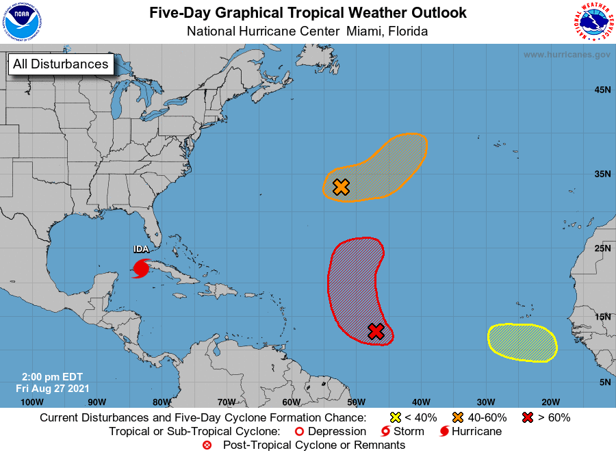
For the North Atlantic...Caribbean Sea and the Gulf of Mexico:
The National Hurricane Center is issuing advisories on recently
upgraded Hurricane Ida, located over the northwestern Caribbean Sea
near the Isle of Youth.
1. An elongated area of low pressure located over the central Atlantic
several hundred miles east of Bermuda is producing disorganized
showers and a couple of thunderstorms. Environmental conditions
are expected to be marginally conducive for development, however, a
tropical depression could still form over the weekend. The system
is expected to drift eastward through tonight and Saturday, then
accelerate northeastward Sunday toward the central north Atlantic.
* Formation chance through 48 hours...medium...40 percent.
* Formation chance through 5 days...medium...60 percent.
2. Showers and thunderstorms associated with a tropical wave located
about midway between the Cabo Verde Islands and the Lesser Antilles
have become a little better organized today. Additional
development of this system is expected, and a tropical depression
is likely to form later tonight or Saturday before it moves into an
environment of stronger upper-level winds and slightly cooler
waters. The disturbance is forecast to move west-northwestward
through tonight, then turn northward Saturday.
* Formation chance through 48 hours...high...80 percent.
* Formation chance through 5 days...high...80 percent.
3. Another tropical wave is expected to emerge off of the west African
coast by the middle of next week. Afterwards, environmental
conditions appear marginally conducive for gradual development
toward the end of next week as the system moves west-northwestward
to northwestward at 10 to 15 mph.
* Formation chance through 48 hours...low...near 0 percent.
* Formation chance through 5 days...low...20 percent.
Forecaster Roberts