ZCZC MIATWOAT ALL
TTAA00 KNHC DDHHMM
Tropical Weather Outlook
NWS National Hurricane Center Miami FL
200 AM EDT Thu Aug 26 2021
For the North Atlantic...Caribbean Sea and the Gulf of Mexico:
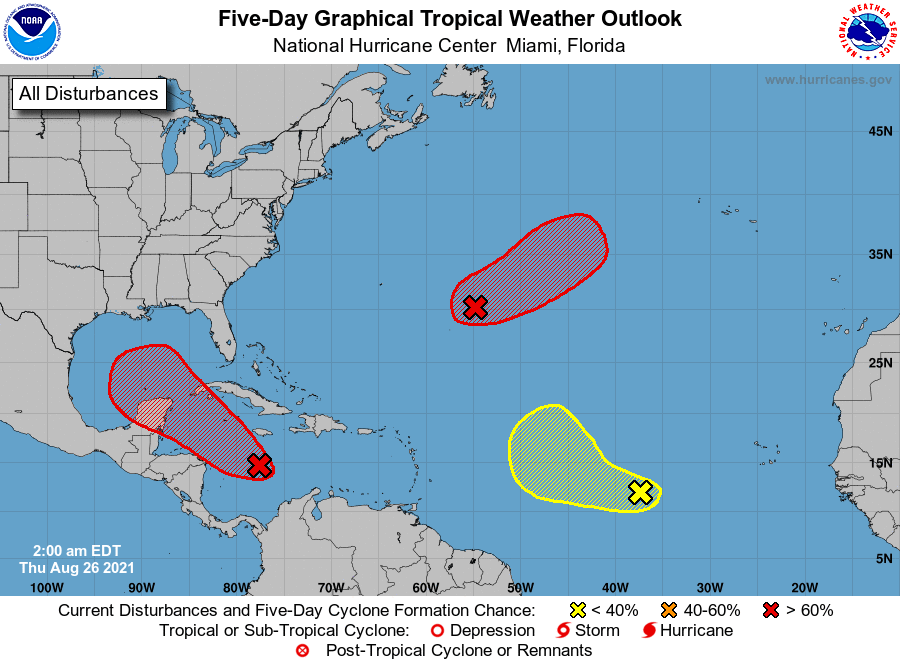
1. Shower and thunderstorm activity is gradually becoming better
organized in association with a trough of low pressure located a
couple hundred miles south of Jamaica. While recent satellite wind
data indicate that the system does not yet have a well-defined
circulation, environmental conditions remain conducive for
additional development, and a tropical depression is expected to
form later today or tomorrow. The system is forecast to move
northwestward over the northwestern Caribbean Sea later today, near
Cuba and the Yucatan Peninsula of Mexico on Friday, and into the
Gulf of Mexico this weekend. Regardless of development, heavy
rainfall and flooding will be possible through the weekend in
portions of Central America, the Yucatan Peninsula, Jamaica, the
Cayman Islands, and Cuba. In addition, this system could bring
dangerous impacts from storm surge, wind, and heavy rainfall to
portions of the coasts of Louisiana, Texas, and the Mexican state of
Tamaulipas late this weekend and early next week. However,
uncertainty remains large since the system has yet to form.
Interests in these areas should closely monitor the progress of this
system and ensure they have their hurricane plan in place. An Air
Force Reserve reconnaissance aircraft is scheduled to investigate
the system later today, if necessary.
* Formation chance through 48 hours...high...80 percent.
* Formation chance through 5 days...high...90 percent.
2. A broad trough of low pressure is producing disorganized showers and
thunderstorms over the central tropical Atlantic about 650 miles
east-southeast of Bermuda. Environmental conditions are forecast to
be generally conducive for development, and a tropical depression
is likely to form late this week or this weekend while the system
moves slowly northeastward over the central Atlantic.
* Formation chance through 48 hours...medium...40 percent.
* Formation chance through 5 days...high...80 percent.
3. A tropical wave over the far eastern tropical Atlantic located
several hundred miles west-southwest of the Cabo Verde Islands is
producing disorganized showers and thunderstorms. Some development
of this system is possible over the next several days while it moves
west-northwestward at 10 to 15 mph over the eastern tropical
Atlantic. Upper-level winds are forecast to become less conducive
for development by early next week.
* Formation chance through 48 hours...low...20 percent.
* Formation chance through 5 days...low...30 percent.
Forecaster Papin/Beven