ZCZC MIATWOAT ALL
TTAA00 KNHC DDHHMM
Tropical Weather Outlook
NWS National Hurricane Center Miami FL
200 PM EDT Mon Aug 23 2021
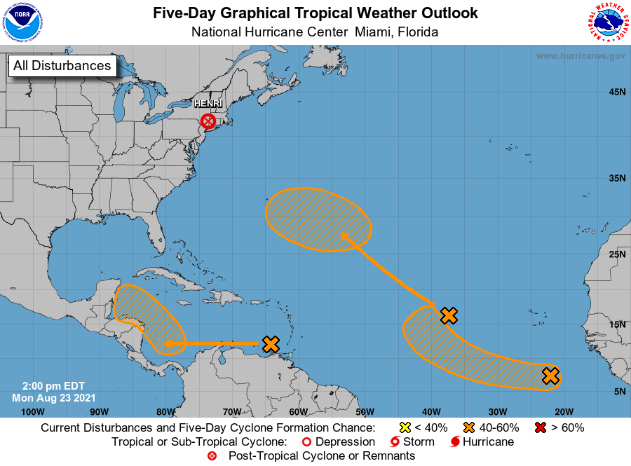
For the North Atlantic...Caribbean Sea and the Gulf of Mexico:
The Weather Prediction Center is issuing Public Advisories on
Tropical Depression Henri, located inland over southern New
England.
1. A broad low pressure system is producing disorganized showers and
thunderstorms over the eastern tropical Atlantic more than 700 miles
west of the Cabo Verde Islands. Little development is expected
during the next couple of days due to only marginally conducive
ocean temperatures. Thereafter, however, some gradual development
will be possible through the end of the week while the system moves
northwestward at 10 to 15 mph over the central Atlantic.
* Formation chance through 48 hours...low...10 percent.
* Formation chance through 5 days...medium...40 percent.
2. A tropical wave located over the eastern Caribbean Sea is expected
to form a broad area of low pressure over the southwestern Caribbean
Sea by late week. Thereafter, environmental conditions are forecast
to become favorable for gradual development while the system moves
west-northwestward over the northwestern Caribbean Sea.
* Formation chance through 48 hours...low...near 0 percent.
* Formation chance through 5 days...medium...40 percent.
3. Another area of disturbed weather has developed in association with
a low pressure system located over the far eastern tropical Atlantic
more than 500 miles south-southeast of the Cabo Verde Islands. Some
slow development will be possible over the next several days while
the disturbance moves westward to west-northwestward at around to
15 mph over the eastern tropical Atlantic.
* Formation chance through 48 hours...low...10 percent.
* Formation chance through 5 days...medium...40 percent.
Public advisories issued by the Weather Prediction Center on
Tropical Depression Henri can be found under AWIPS header TCPAT3,
WMO header WTNT33 KWNH, and on the web at
http://www.wpc.ncep.noaa.gov
Forecaster Stewart