ZCZC MIATWOAT ALL
TTAA00 KNHC DDHHMM
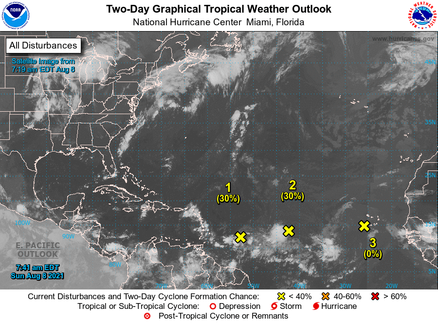
Tropical Weather Outlook
NWS National Hurricane Center Miami FL
800 AM EDT Sun Aug 8 2021
For the North Atlantic...Caribbean Sea and the Gulf of Mexico:
1. An area of low pressure is producing disorganized showers and
thunderstorms over the tropical Atlantic several hundred miles east
of the Windward Islands. Environmental conditions are expected
to be favorable to support some gradual development, and this
system could become a tropical depression while it moves west-
northwestward at 10 to 15 mph. The disturbance is forecast to
reach portions of the Lesser Antilles late Monday and then move
across the eastern Caribbean Sea and Greater Antilles through the
middle of this week. Interests in those areas should monitor the
progress of this system, as it could bring locally heavy rainfall
and gusty winds to portions of that area.
* Formation chance through 48 hours...low...30 percent.
* Formation chance through 5 days...medium...40 percent.
2. Showers and thunderstorms associated with an area of low pressure
located over the tropical Atlantic about midway between the Cabo
Verde Islands and the Lesser Antilles have become more concentrated
since yesterday. Environmental conditions are expected to become a
little more favorable for gradual development, and this system
could become a tropical depression within the next few days. The
system is forecast to move slowly toward the west-southwest or west
during the next couple of days, and then move a little faster toward
the west by mid-week.
* Formation chance through 48 hours...low...30 percent.
* Formation chance through 5 days...medium...40 percent.
3. Showers and thunderstorms associated with a broad area of low
pressure located about a hundred miles west of the southwesternmost
Cabo Verde Islands have diminished since yesterday. Strong
upper-level winds and cooler waters are expected to prevent the
development of this system while it moves toward the west or
west-northwest.
* Formation chance through 48 hours...low...near 0 percent.
* Formation chance through 5 days...low...near 0 percent.
Forecaster Brown