ZCZC MIATWOAT ALL
TTAA00 KNHC DDHHMM
Tropical Weather Outlook
NWS National Hurricane Center Miami FL
800 AM EDT Mon Jun 14 2021
For the North Atlantic...Caribbean Sea and the Gulf of Mexico:
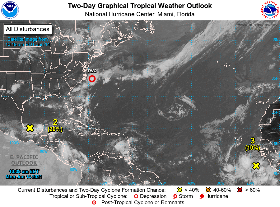
1. Satellite, radar and surface observations indicate that a
well-defined low pressure system located about 90 miles southeast of
Cape Hatteras, North Carolina, is acquiring more tropical
characteristics. Environmental conditions appear conducive for
further development, and a tropical depression or tropical storm is
likely to form later today or tonight. This system is expected to
move northeastward away from the United States and move over colder
waters south of Nova Scotia on Wednesday, ending any opportunity for
further development by midweek.
* Formation chance through 48 hours...high...70 percent.
* Formation chance through 5 days...high...70 percent.
2. Showers and thunderstorms located over the Bay of Campeche are
associated with a broad low pressure area. Gradual development of
this disturbance is possible during the next couple of days while
it meanders near the coast of Mexico, and a tropical depression
could form late in the week when the system moves northward into
the central Gulf of Mexico. Regardless of development, heavy
rainfall is possible over portions of Central America and southern
Mexico during the next several days. Please consult products from
your local meteorological service for more information.
* Formation chance through 48 hours...low...20 percent.
* Formation chance through 5 days...medium...60 percent.
3. A strong tropical wave just offshore of west Africa is producing
disorganized shower and thunderstorm activity. Some development
of this system is possible during the next few days before a
combination of dry air aloft and strong upper-level winds limit any
chance of formation while the wave is over the central tropical
Atlantic Ocean late week.
* Formation chance through 48 hours...low...10 percent.
* Formation chance through 5 days...low...20 percent.
Forecaster Blake