ZCZC MIATWOEP ALL
TTAA00 KNHC DDHHMM
Tropical Weather Outlook
NWS National Hurricane Center Miami FL
1100 AM PDT Sat Jun 12 2021
For the eastern North Pacific...east of 140 degrees west longitude:
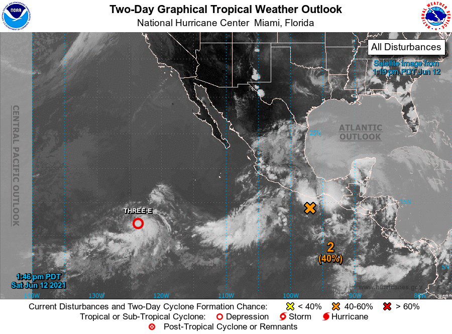
1. Recent satellite and microwave imagery indicate that the area of low
pressure located about 1100 miles southwest of the southern tip of
the Baja California peninsula has become better-defined while
associated shower and thunderstorm activity is showing signs of
organization. Therefore, this system will likely become a tropical
depression later today or tonight as it moves slowly westward. Early
next week, conditions are expected to become unfavorable for further
development.
* Formation chance through 48 hours...high...90 percent.
* Formation chance through 5 days...high...90 percent.
2. Showers and thunderstorms remain poorly organized in association
with a weak area of low pressure located about a hundred miles
south-southwest of Puerto Angel, Mexico. Environmental conditions
appear to be somewhat conducive for further development over the
next day or so, and a short-lived tropical depression could still
form during that time. By early next week, the system is forecast to
interact with land and a larger disturbance developing to its north,
and further development is not anticipated. Regardless of
development, heavy rainfall will be possible over portions of
Central America and southern Mexico through early next week. See
products from your local meteorological service for more
information.
* Formation chance through 48 hours...medium...40 percent.
* Formation chance through 5 days...medium...40 percent.
Forecaster Latto