ZCZC MIATWOAT ALL
TTAA00 KNHC DDHHMM
Tropical Weather Outlook
NWS National Hurricane Center Miami FL
200 AM EDT Wed Sep 16 2020
For the North Atlantic...Caribbean Sea and the Gulf of Mexico:
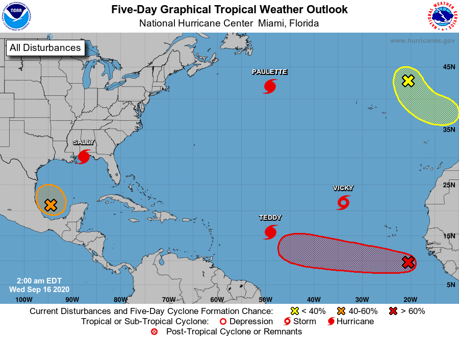
The National Hurricane Center is issuing advisories on Hurricane
Paulette, located several hundred miles south of Cape Race,
Newfoundland, on Hurricane Sally, centered near the northern Gulf
coast, on Tropical Storm Teddy, located over the central tropical
Atlantic, and on Tropical Storm Vicky, located over the eastern
tropical Atlantic.
1. An area of low pressure over the southwestern Gulf of
Mexico is producing showers and thunderstorms that are showing some
signs of organization Upper-level winds are forecast to
gradually become more conducive for development, and a tropical
depression could form late this week while the low meanders over the
southern Gulf of Mexico for the next several days.
* Formation chance through 48 hours...low...20 percent.
* Formation chance through 5 days...medium...40 percent.
2. Showers and thunderstorms associated with an area of low pressure
located a few hundred miles south-southeast of the Cabo Verde
Islands have changed little during the past several hours.
Environmental conditions are conducive for development of this
system, however, and a tropical depression is likely to form during
the next few days while the system moves generally westward at 10 to
15 mph.
* Formation chance through 48 hours...medium...50 percent.
* Formation chance through 5 days...high...70 percent.
3. A non-tropical area of low pressure is located over the far
northeastern Atlantic Ocean a few hundred miles northeast of the
Azores. This system could acquire some subtropical characteristics
while it moves southeastward and eastward at about 10 mph during
the next few days. For more information on this system, see
High Seas Forecasts issued by Meteo France.
* Formation chance through 48 hours...low...20 percent.
* Formation chance through 5 days...low...20 percent.
High Seas Forecasts issued by Meteo France can be found under WMO
header FQNT50 LFPW and available on the web at
www.meteofrance.com/previsions-meteo-marine/bulletin/grandlarge/
metarea2
Forecaster Blake