ZCZC MIATWOAT ALL
TTAA00 KNHC DDHHMM
Tropical Weather Outlook
NWS National Hurricane Center Miami FL
800 AM EDT Tue Sep 15 2020
For the North Atlantic...Caribbean Sea and the Gulf of Mexico:
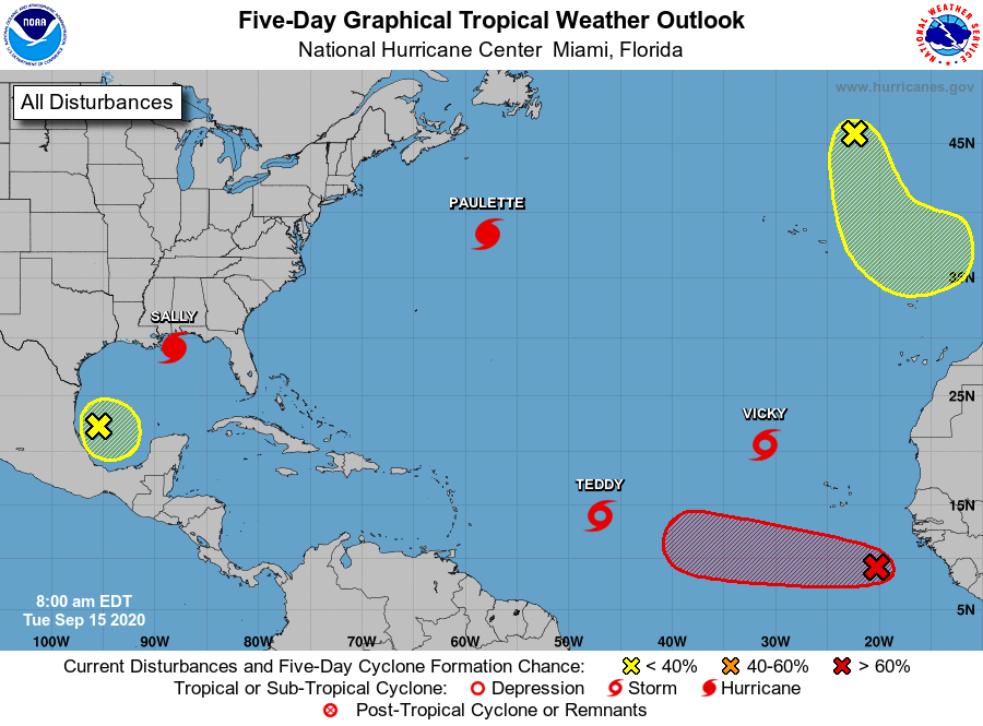
The National Hurricane Center is issuing advisories on Hurricane
Paulette, located several hundred miles northeast of Bermuda,
on Hurricane Sally, centered over the north-central Gulf of Mexico,
on Tropical Storm Teddy, located over the central tropical
Atlantic, and on Tropical Storm Vicky, located over the eastern
tropical Atlantic.
1. A broad area of low pressure over the southwestern Gulf of Mexico is
producing limited shower or thunderstorm activity. Any development
of this system should be slow to occur while the low meanders over
the southern Gulf of Mexico for the next several days.
* Formation chance through 48 hours...low...10 percent.
* Formation chance through 5 days...low...20 percent.
2. Showers and thunderstorms associated with an area of low pressure,
located a few hundred miles south-southeast of the Cabo Verde
Islands, gradually continue to become better organized.
Environmental conditions are conducive for further development of
this system, and a tropical depression is likely to form during the
next few days while the system moves generally westward at 10 to 15
mph.
* Formation chance through 48 hours...medium...50 percent.
* Formation chance through 5 days...high...70 percent.
3. A non-tropical area of low pressure is located over the far
northeastern Atlantic Ocean several hundred miles northeast of the
Azores. This system is forecast to move south-southeastward during
the next few days where it will encounter warmer oceanic
temperatures, which could allow the low to gradually acquire some
tropical or subtropical characteristics this week.
* Formation chance through 48 hours...low...10 percent.
* Formation chance through 5 days...low...20 percent.
Forecaster Roberts