ZCZC MIATWOAT ALL
TTAA00 KNHC DDHHMM
Tropical Weather Outlook
NWS National Hurricane Center Miami FL
200 AM EDT Sun Sep 13 2020
For the North Atlantic...Caribbean Sea and the Gulf of Mexico:
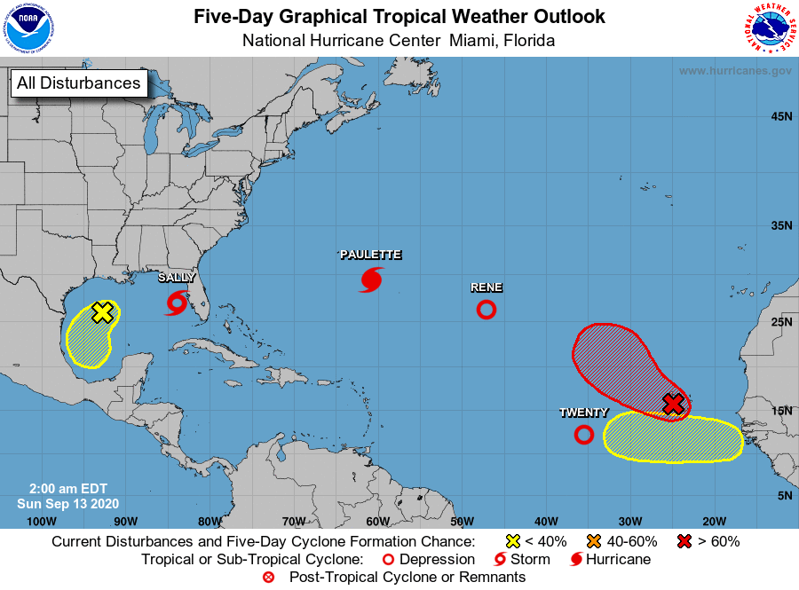
The National Hurricane Center is issuing advisories on recently
upgraded Hurricane Paulette and Tropical Depression Rene, both
located over the central Atlantic Ocean, on Tropical Storm Sally,
centered over the southeastern Gulf of Mexico, and on Tropical
Depression Twenty, located over the eastern tropical Atlantic.
1. A surface trough over the west-central Gulf of Mexico is producing
limited shower activity. While some slow development of this system
is possible, strong upper-level winds associated with Tropical
Storm Sally will probably limit the chances of tropical cyclone
formation through Monday. The disturbance is forecast to move
southwestward and then southward over the west-central and
southwestern Gulf of Mexico through the next few days.
* Formation chance through 48 hours...low...10 percent.
* Formation chance through 5 days...low...20 percent.
2. Showers and thunderstorms located near and west of the Cabo Verde
Islands are associated with a broad area of low pressure.
Environmental conditions support some additional development, and
a tropical depression could form over the far eastern tropical
Atlantic during the next couple of days while the system moves
slowly west-northwestward. By mid-week, however, upper-level winds
should become less conducive for development.
* Formation chance through 48 hours...medium...60 percent.
* Formation chance through 5 days...high...70 percent.
3. A tropical wave is forecast to move off the west coast of Africa
around mid-week. Some gradual development of the system will be
possible thereafter as the disturbance moves slowly westward over
the far eastern tropical Atlantic.
* Formation chance through 48 hours...low...near 0 percent.
* Formation chance through 5 days...low...20 percent.
Public Advisories on Tropical Depression Twenty are issued under
WMO header WTNT35 KNHC and under AWIPS header MIATCPAT5.
Forecast/Advisories on Tropical Depression Twenty are issued under
WMO header WTNT25 KNHC and under AWIPS header MIATCMAT5.
Forecaster Stewart