ZCZC MIATWOAT ALL
TTAA00 KNHC DDHHMM
Tropical Weather Outlook
NWS National Hurricane Center Miami FL
800 AM EDT Fri Sep 4 2020
For the North Atlantic...Caribbean Sea and the Gulf of Mexico:
The National Hurricane Center is issuing advisories on Tropical
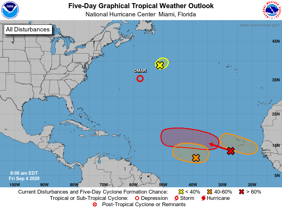
Depression Omar, located about 400 miles east-northeast of Bermuda.
1. A non-tropical area of low pressure is located over the
north-central Atlantic about 500 miles south-southeast of Cape
Race Newfoundland. This low is expected to move
north-northeastward near 15 mph, and some slight subtropical or
tropical development of this system is possible before it reaches
cooler waters tonight.
* Formation chance through 48 hours...low...20 percent.
* Formation chance through 5 days...low...20 percent.
2. A nearly stationary broad area of low pressure is located over the
east-central tropical Atlantic about midway between the west coast
of Africa and the Windward Islands. This system continues to
produce disorganized showers and thunderstorms, and gradual
development is possible after the larger tropical wave located near
the Cabo Verde Islands passes to the north of this system on Sunday.
* Formation chance through 48 hours...low...20 percent.
* Formation chance through 5 days...medium...40 percent.
3. A tropical wave located just west of the Cabo Verde Islands is
producing a large area of disorganized showers and thunderstorms.
Gradual development of this system is expected as it moves
westward to west-northwestward, and a tropical depression is likely
to form early next week when the system reaches the central
tropical Atlantic.
* Formation chance through 48 hours...low...20 percent.
* Formation chance through 5 days...high...70 percent.
4. Another tropical wave is forecast to move off the west coast of
Africa on Sunday. Gradual development of this system is then
expected, and a tropical depression could form by the middle of
next week while it moves generally westward over the far eastern
tropical Atlantic.
* Formation chance through 48 hours...low...near 0 percent.
* Formation chance through 5 days...medium...50 percent.
Forecaster Cangialosi