ZCZC MIATWOAT ALL
TTAA00 KNHC DDHHMM
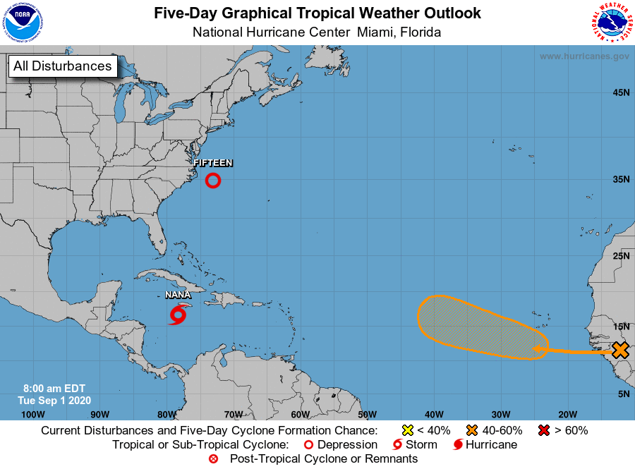
Tropical Weather Outlook
NWS National Hurricane Center Miami FL
800 AM EDT Tue Sep 1 2020
For the North Atlantic...Caribbean Sea and the Gulf of Mexico:
The National Hurricane Center is issuing advisories on Tropical
Depression Fifteen, located more than 100 miles southeast of
Cape Hatteras, North Carolina.
1. A well-organized cluster of showers and thunderstorms associated
with a tropical wave continues to move quickly westward across the
central Caribbean Sea. Although the disturbance does not yet have a
well-defined circulation center, ship observations indicate that
tropical-storm-force winds are occurring in the northern portion of
wave to the southeast of Jamaica, which will spread near or just
south of Jamaica later this morning and into this afternoon.
Environmental conditions are expected to become a little more
conducive for development, and a tropical depression or a tropical
storm is likely to form during the next day or so before the
system reaches Central America Wednesday night. Locally heavy rains
and gusty winds are possible on Jamaica today, and interests there,
as well as in northern Nicaragua, Honduras, Belize, Guatemala, and
the Yucatan Peninsula, should monitor the progress of this system.
An Air Force Reserve reconnaissance aircraft is currently en route
to investigate the disturbance.
Potential tropical cyclone or tropical cyclone advisories will
likely be issued later today, along with watches and warnings.
Additional information on this system can be found in High Seas
Forecasts issued by the National Weather Service.
* Formation chance through 48 hours...high...80 percent.
* Formation chance through 5 days...high...80 percent.
2. A tropical wave is expected to emerge off the coast of Africa in a
day or so. Gradual development of this system will be possible
through the end of the week while it moves slowly westward over the
far eastern tropical Atlantic Ocean.
* Formation chance through 48 hours...low...near 0 percent.
* Formation chance through 5 days...medium...40 percent.
High Seas Forecasts issued by the National Weather Service can be
found under AWIPS header NFDHSFAT1, WMO header FZNT01 KWBC, and
online at ocean.weather.gov/shtml/NFDHSFAT1.php.
Public Advisories on Tropical Depression Fifteen are issued under
WMO header WTNT35 KNHC and under AWIPS header MIATCPAT5.
Forecast/Advisories on Tropical Depression Fifteen are issued under
WMO header WTNT25 KNHC and under AWIPS header MIATCMAT5.
Forecaster Stewart