ZCZC MIATWOAT ALL
TTAA00 KNHC DDHHMM
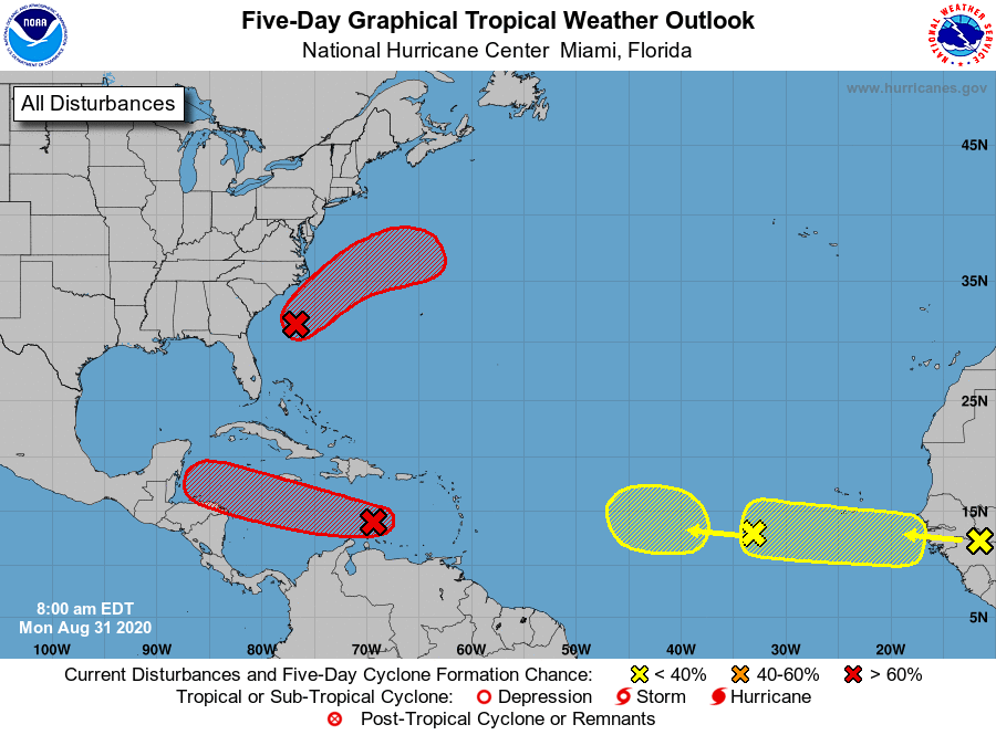
Tropical Weather Outlook
NWS National Hurricane Center Miami FL
800 AM EDT Mon Aug 31 2020
For the North Atlantic...Caribbean Sea and the Gulf of Mexico:
1. A broad area of low pressure associated with a tropical wave over
the central Caribbean Sea has changed little in organization since
yesterday. However, environmental conditions are expected to
gradually become more conducive for development, and a tropical
depression is likely to form during the next couple of days while
the system moves westward at at 15 to 20 mph. Interests in Jamaica,
Honduras, Belize, Guatemala and the Yucatan peninsula should monitor
the progress of this disturbance.
* Formation chance through 48 hours...high...70 percent.
* Formation chance through 5 days...high...80 percent.
2. An area of low pressure is located about 150 miles south-southeast
of Wilmington, North Carolina. This system has become better
organized overnight, and a tropical depression is likely to form
within a day or so while the system moves northeastward, near but
offshore of the southeastern coast of the United States, and then
away from land. An Air Force Reserve Hurricane Hunter aircraft is
scheduled to investigate the system this afternoon if necessary.
* Formation chance through 48 hours...high...70 percent.
* Formation chance through 5 days...high...70 percent.
3. A tropical wave is expected to emerge off the coast of Africa in a
couple of days. Gradual development of this system will be possible
through the end of the week while it moves slowly westward over the
far eastern tropical Atlantic Ocean.
* Formation chance through 48 hours...low...near 0 percent.
* Formation chance through 5 days...low...30 percent.
4. Another tropical wave is located over the eastern Atlantic Ocean,
several hundred miles southwest of the Cabo Verde Islands. This
system is producing little shower activity, and further development
of this system is not expected.
* Formation chance through 48 hours...low...near 0 percent.
* Formation chance through 5 days...low...10 percent.
Forecaster Blake