ZCZC MIATWOEP ALL
TTAA00 KNHC DDHHMM
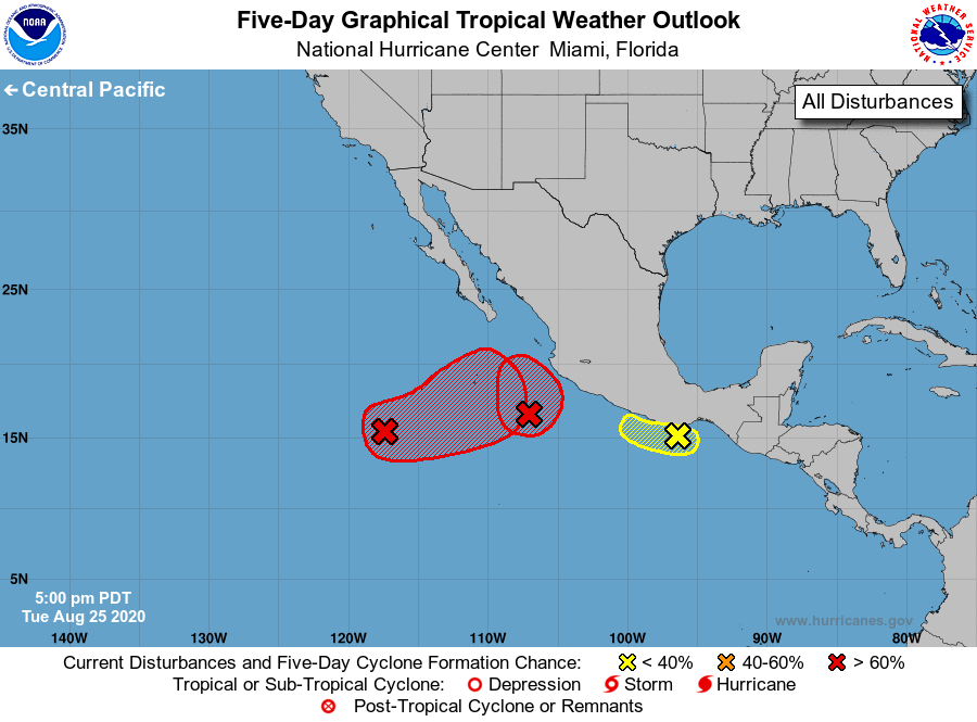
Tropical Weather Outlook
NWS National Hurricane Center Miami FL
500 PM PDT Tue Aug 25 2020
For the eastern North Pacific...east of 140 degrees west longitude:
1. A low pressure system located a few hundred miles south-southeast of
the southern tip of the Baja California peninsula continues to show
signs of organization. This system will likely become a tropical
depression or tropical storm during the next day or two while it
moves slowly east-northeastward or northeastward, near or just west
of the southwestern coast of Mexico. For more information on this
system, see High Seas forecasts issued by the National Weather
Service.
* Formation chance through 48 hours...high...90 percent.
* Formation chance through 5 days...high...90 percent.
2. An elongated area of low pressure near the coast of south-central
Mexico continues to produce disorganized showers and thunderstorms.
Development of this system has become unlikely due to unfavorable
upper-level winds and close proximity to land. Regardless of
development, areas of heavy rainfall and flash flooding are likely
in southeastern Mexico and northern Central America during the next
several days.
* Formation chance through 48 hours...low...20 percent.
* Formation chance through 5 days...low...20 percent.
3. Another low pressure system is located several hundred miles
southwest of the southern tip of the Baja California peninsula.
Although this system is currently producing limited shower and
thunderstorm activity, its circulation has become better defined
during the past several hours. Some additional development of the
disturbance is expected and it will likely become a tropical
depression during the next few days while it moves slowly
east-northeastward to northeastward.
* Formation chance through 48 hours...medium...60 percent.
* Formation chance through 5 days...high...70 percent.
High Seas Forecasts issued by the National Weather Service
can be found under AWIPS header NFDHSFEPI, WMO header FZPN02
KWBC, and on the web at ocean.weather.gov/shtml/NFDHSFEPI.php
Forecaster Zelinsky