ZCZC MIATWOAT ALL
TTAA00 KNHC DDHHMM
Tropical Weather Outlook
NWS National Hurricane Center Miami FL
800 AM EDT Thu Aug 20 2020
For the North Atlantic...Caribbean Sea and the Gulf of Mexico:
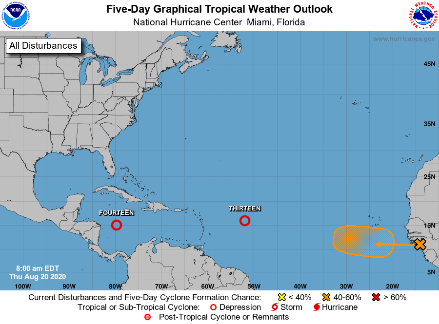
The National Hurricane Center is issuing advisories on Tropical
Depression Thirteen, located several hundred miles east of the
northern Leeward Islands.
1. Showers and thunderstorms continue to become better organized in
association with a tropical wave and accompanying broad area of low
pressure over the central Caribbean Sea. Satellite imagery
suggests that the circulation is becoming better defined and if
these development trends continue, a tropical depression is likely
to form today or tonight as the system approaches the northwestern
Caribbean Sea. Interests in Honduras and the Yucatan Peninsula
should closely monitor the progress of this system. Regardless of
development, this disturbance will likely produce heavy rains across
a large portion of Central America and southeastern Mexico late this
week and this weekend. An Air Force Reserve reconnaissance aircraft
is scheduled to investigate the disturbance system later today.
* Formation chance through 48 hours...high...90 percent.
* Formation chance through 5 days...high...90 percent.
2. A tropical wave over western Africa is producing disorganized
showers and thunderstorms near the Africa coast. This wave is
expected to move over the far eastern tropical Atlantic on Friday,
and some slow development is possible through the weekend while it
moves west-northwestward at 15 to 20 mph across the eastern tropical
Atlantic.
* Formation chance through 48 hours...low...20 percent.
* Formation chance through 5 days...medium...40 percent.
Public Advisories on Tropical Depression Thirteen are issued under
WMO header WTNT33 KNHC and under AWIPS header MIATCPAT3.
Forecast/Advisories on Tropical Depression Thirteen are issued
under WMO header WTNT23 KNHC and under AWIPS header MIATCMAT3.
Forecaster Latto