ZCZC MIATWOEP ALL
TTAA00 KNHC DDHHMM
Tropical Weather Outlook
NWS National Hurricane Center Miami FL
1100 PM PDT Fri Aug 14 2020
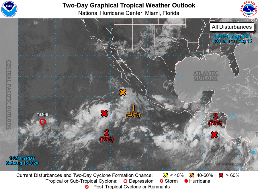
For the eastern North Pacific...east of 140 degrees west longitude:
The National Hurricane Center is issuing advisories on Tropical
Depression Ten-E, located more than 1500 miles west-southwest
of the southern tip of the Baja California peninsula.
1. An area of low pressure located about 150 miles southwest of the
southern tip of the Baja California peninsula has become a little
better defined since yesterday. However, the associated shower
activity remains limited. While some additional development of this
system is possible, the low is forecast to move over cooler waters
on Saturday and the chance of this system becoming a tropical
depression appears to be decreasing.
* Formation chance through 48 hours...medium...40 percent.
* Formation chance through 5 days...medium...40 percent.
2. Another area of disturbed weather associated with a broad area of
low pressure is located about 700 miles southwest of the southern
tip of the Baja California peninsula. Environmental conditions are
expected to be conducive for the development of this system, and it
is likely to become a tropical depression while it moves slowly
north-northwestward or northward during the next few days.
* Formation chance through 48 hours...high...70 percent.
* Formation chance through 5 days...high...70 percent.
3. A trough of low pressure continues to produce disorganized
showers and thunderstorms just offshore of the Pacific coast of
Central America. Conditions are expected to be conducive for a low
pressure system to develop from this trough over the next day or
so, and a tropical depression or storm is likely to form this
weekend or early next week while the system moves generally
west-northwestward just offshore of the southwestern coast of
Mexico.
* Formation chance through 48 hours...high...70 percent.
* Formation chance through 5 days...high...90 percent.
Forecaster Pasch