ZCZC MIATWOEP ALL
TTAA00 KNHC DDHHMM
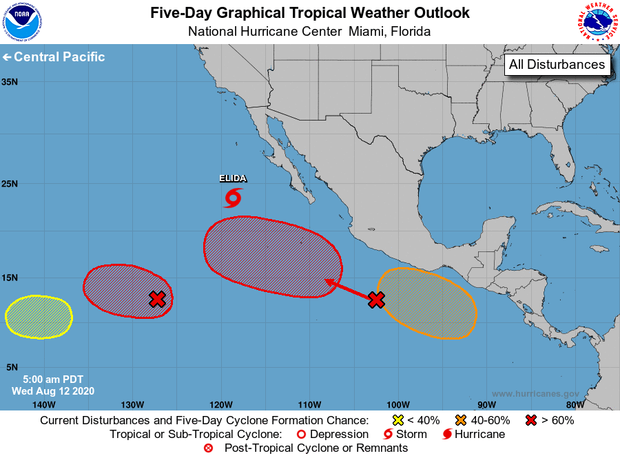
Tropical Weather Outlook
NWS National Hurricane Center Miami FL
500 AM PDT Wed Aug 12 2020
For the eastern North Pacific...east of 140 degrees west longitude:
The National Hurricane Center is issuing advisories on Hurricane
Elida, located about 500 miles west of the southern tip of the Baja
California peninsula.
1. An elongated area of low pressure located about 1300 miles
southwest of the southern tip of the Baja California continues to
produce a broad area of cloudiness and disorganized showers and
thunderstorms. Environmental conditions are conducive for
development, and a tropical depression is likely to form within the
next couple of days while the system moves slowly
west-northwestward.
* Formation chance through 48 hours...high...70 percent.
* Formation chance through 5 days...high...90 percent.
2. A large area of disturbed weather associated with a trough of low
pressure extends from just west of the Gulf of Tehuantepec
southwestward for several hundred miles. Environmental conditions
appear conducive for development, and a tropical depression is
likely to form during the next few days before the system reaches
cooler waters over the weekend. This system is forecast to move
west-northwestward at about 15 mph away from the coast of
southwestern Mexico.
* Formation chance through 48 hours...medium...60 percent.
* Formation chance through 5 days...high...90 percent.
3. Another area of low pressure is expected to form in a few days over
the far eastern portion of the basin to the south of the coast of
Central America. Conditions are expected to be conducive for
development, and a tropical depression could form this weekend
or early next week while it moves generally west-northwestward just
offshore the coast of Mexico.
* Formation chance through 48 hours...low...near 0 percent.
* Formation chance through 5 days...medium...60 percent.
4. Another area of disturbed weather is forecast to form near or west
of the border between the National Hurricane Center and Central
Pacific Hurricane Center areas of responsibility. Some subsequent
gradual development of this system is possible later this week while
the system moves slowly westward in the central Pacific basin.
Future information on this system will be included in Tropical
Weather Outlooks issued by the Central Pacific Hurricane Center.
* Formation chance through 48 hours...low...near 0 percent.
* Formation chance through 5 days...low...30 percent.
The Central Pacific Tropical Weather Outlook is issued under WMO
header ACPN50 PHFO and under AWIPS header HFOTWOCP, and is
available on the web at www.nhc.noaa.gov/?cpac
Forecaster Berg