ZCZC MIATWOAT ALL
TTAA00 KNHC DDHHMM
Tropical Weather Outlook
NWS National Hurricane Center Miami FL
200 PM EDT Mon Jul 20 2020
For the North Atlantic...Caribbean Sea and the Gulf of Mexico:
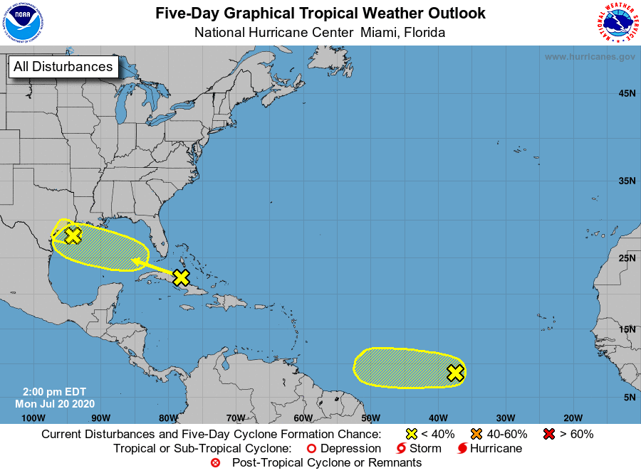
1. Disorganized showers and thunderstorms over Cuba, the central and
northwestern Bahamas, and the adjacent Atlantic waters are
associated with a tropical wave. This system is expected to move
west-northwestward through the Straits of Florida today and
tonight, over the southeastern Gulf of Mexico by Tuesday, across
the central Gulf on Wednesday, and reach the northwestern Gulf on
Thursday. Environmental conditions could become a little more
conducive for development of this system once it reaches the Gulf
of Mexico. An Air Force Reserve Hurricane Hunter aircraft is
scheduled to investigate the system tomorrow, if necessary.
* Formation chance through 48 hours...low...20 percent.
* Formation chance through 5 days...low...20 percent.
2. Shower activity associated with a tropical wave located about 1000
miles west-southwest of the Cabo Verde Islands has changed little
in organization during the past several hours. Environmental
conditions are expected to be marginally conducive for development
of this system during the next few days while it moves westward at
10 to 15 mph over the tropical Atlantic. By Friday and over the
weekend, conditions are forecast to become less favorable for
tropical cyclone formation.
* Formation chance through 48 hours...low...20 percent.
* Formation chance through 5 days...low...20 percent.
3. Surface observations indicate that a weak low pressure area is
located over the northwestern Gulf of Mexico. The associated
shower and thunderstorm activity has become a little better
organized during the past several hours. However, the system is
expected to move inland over Texas tonight or Tuesday before
significant additional development can occur. Regardless of
development, locally heavy rainfall is possible over portions of
southeastern Texas and southern Louisiana during the next day or
two.
* Formation chance through 48 hours...low...20 percent.
* Formation chance through 5 days...low...20 percent.
Forecaster Beven