ZCZC MIATWOEP ALL
TTAA00 KNHC DDHHMM
Tropical Weather Outlook
NWS National Hurricane Center Miami FL
1100 PM PDT Tue Jun 23 2020
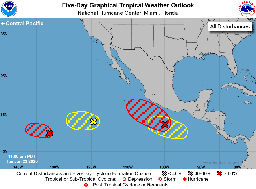
For the eastern North Pacific...east of 140 degrees west longitude:
1. Showers and thunderstorms have increased during the past several
hours in association with a small area of low pressure located
about 1700 miles southwest of the southern tip of the Baja
California peninsula. Environmental conditions are expected to
support further thunderstorm activity, and the low is likely to
become a tropical depression during the next couple of days while
it moves slowly toward the west or west-northwest.
* Formation chance through 48 hours...high...70 percent.
* Formation chance through 5 days...high...70 percent.
2. An elongated area of low pressure located several hundred miles
southwest of the southern tip of the Baja California peninsula
continues to produce a wide area of disorganized showers and a few
thunderstorms. Some development of this system is possible during
the next day or two while the system moves westward at about 15 mph
before it moves over cooler waters.
* Formation chance through 48 hours...low...30 percent.
* Formation chance through 5 days...low...30 percent.
3. Disorganized showers and thunderstorms located a few hundred miles
south-southwest of the Gulf of Tehuantepec are associated with a
tropical wave. Environmental conditions are forecast to be
conducive for development, and the system is likely to become a
tropical depression in a few days while it moves west-northwestward
parallel to the coast of Mexico.
* Formation chance through 48 hours...medium...50 percent.
* Formation chance through 5 days...high...80 percent.
4. Another area of low pressure is forecast to form south of the Gulf
of Tehuantepec by late this week. Gradual development of this system
will be possible over the weekend as it moves west-northwestward
parallel to the coast of Mexico.
* Formation chance through 48 hours...low...near 0 percent.
* Formation chance through 5 days...low...30 percent.
Forecaster Blake