ZCZC MIATWOAT ALL
TTAA00 KNHC DDHHMM
Special Tropical Weather Outlook
NWS National Hurricane Center Miami FL
200 AM EDT Sun May 31 2020
For the North Atlantic...Caribbean Sea and the Gulf of Mexico:
Special Tropical Weather Outlook issued to discuss the area of low
pressure over the central Atlantic and the potential for tropical
cyclone formation over the southwestern Gulf of Mexico.
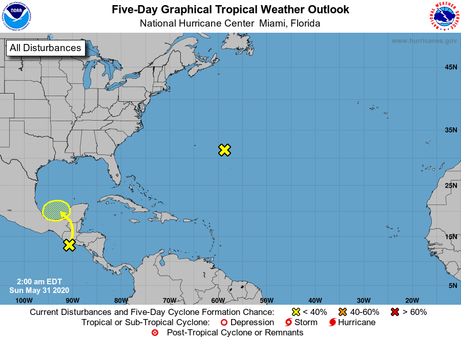
1. An area of low pressure located about 350 miles east of Bermuda is
producing limited shower activity. The low is forecast to move
northeastward at 5 to 10 mph later today, and development is not
expected due to unfavorable environmental conditions.
* Formation chance through 48 hours...low...near 0 percent.
* Formation chance through 5 days...low...near 0 percent.
2. Tropical Depression Two-E, located near the Pacific coasts of
Guatemala and El Salvador, is forecast to move inland and dissipate
over Guatemala or southeastern Mexico by tonight. However, the
remnants are expected to turn northwestward within a broader
developing area of disturbed weather, possibly emerging over the
Bay of Campeche on Monday. If the remnants do move back over
water, environmental conditions appear conducive to support some
redevelopment of the system while it moves little during much of
the upcoming week. Regardless of redevelopment, heavy rainfall is
likely over portions of southern Mexico during the next few days.
The next Special Tropical Weather Outlook will be issued later
this morning by 9 AM EDT.
* Formation chance through 48 hours...low...10 percent.
* Formation chance through 5 days...low...30 percent.
Forecaster Berg