ZCZC MIATWOEP ALL
TTAA00 KNHC DDHHMM
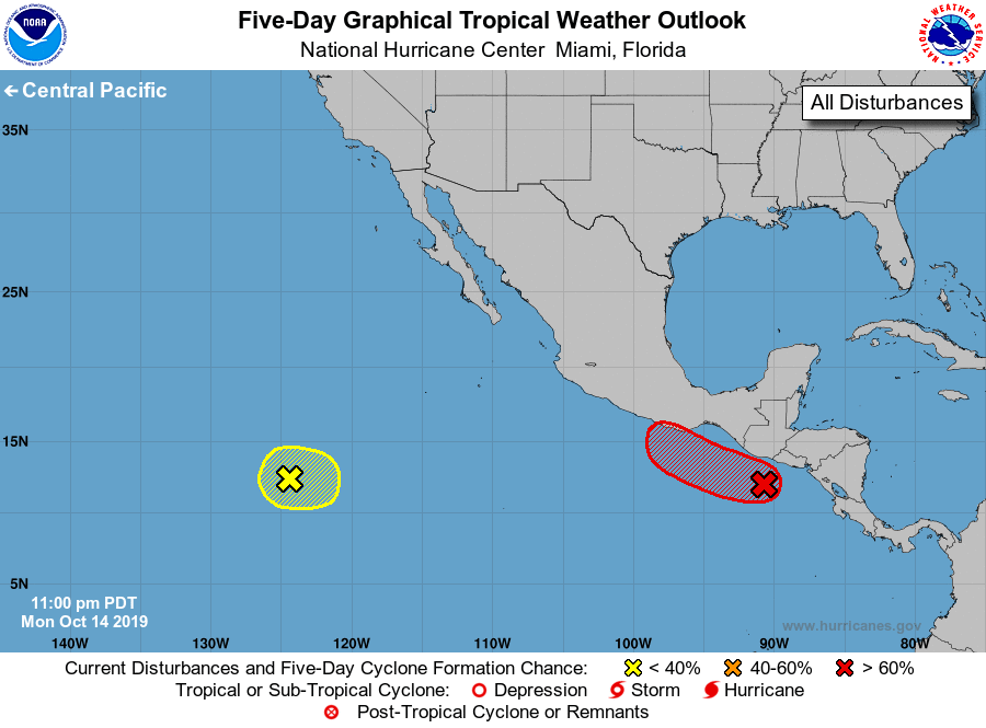
Tropical Weather Outlook
NWS National Hurricane Center Miami FL
1100 PM PDT Mon Oct 14 2019
For the eastern North Pacific...east of 140 degrees west longitude:
1. Showers and thunderstorms have increased near a broad area of low
pressure located a couple of hundred miles south of the coast of
Guatemala. This system has become better organized since yesterday,
and a tropical depression or tropical storm is expected to form
within the next couple of days while the system moves west-
northwestward at about 10 mph close to or over the coast of
southeastern Mexico. Regardless of development, heavy rainfall
currently occurring across Costa Rica, Nicaragua, Honduras and El
Salvador is forecast to spread westward over Guatemala on Tuesday,
and across southern Mexico by Wednesday. These rains could cause
flooding and mudslides, especially in mountainous areas. Interests
in southeastern Mexico should monitor the progress of this system,
and tropical storm watches or warnings are likely going to be
required for a portion of that area on Tuesday.
* Formation chance through 48 hours...high...80 percent.
* Formation chance through 5 days...high...80 percent.
2. A large but disorganized area of showers and thunderstorms centered
about 1200 miles southwest of the southern tip of the Baja
California peninsula is associated with a surface trough. Some
development of this system is possible in a few days while the
system drifts southward or eastward.
* Formation chance through 48 hours...low...near 0 percent.
* Formation chance through 5 days...low...20 percent.
Forecaster Blake