ZCZC MIATWOAT ALL
TTAA00 KNHC DDHHMM
Tropical Weather Outlook
NWS National Hurricane Center Miami FL
800 AM EDT Tue Oct 8 2019
For the North Atlantic...Caribbean Sea and the Gulf of Mexico:
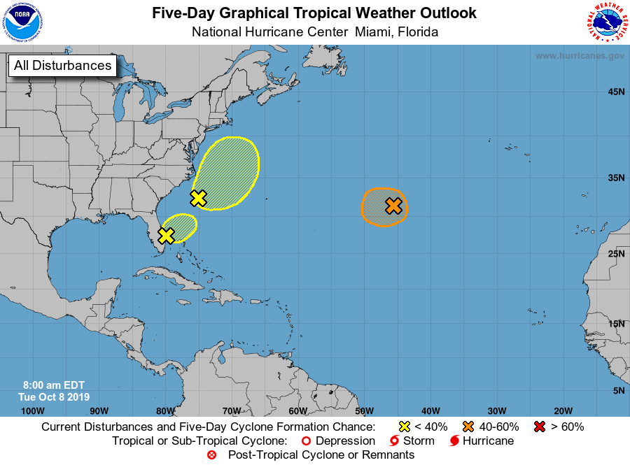
1. A non-tropical low pressure system located over the central Atlantic
between Bermuda and the Azores is producing winds to gale force.
Environmental conditions are forecast to be generally conducive for
the low to acquire some subtropical or tropical characteristics,
and this system could become a tropical or subtropical storm later
today or early Wednesday while it moves slowly westward.
Upper-level winds are expected to become unfavorable for further
development by Wednesday evening. Additional information on this
system can be found in High Seas Forecasts issued by the National
Weather Service.
* Formation chance through 48 hours...medium...40 percent.
* Formation chance through 5 days...medium...40 percent.
2. Showers and thunderstorms over the western Atlantic between the
southeastern coast of the United States and Bermuda are associated
with a broad, non-tropical area of low pressure. This system is
forecast to move northward or northeastward and could acquire some
subtropical characteristics off the east coast of the United States
by the end of the week. Additional information on this system can
also be found in High Seas Forecasts issued by the National Weather
Service.
* Formation chance through 48 hours...low...10 percent.
* Formation chance through 5 days...low...30 percent.
3. A trough of low pressure extending across the southern Florida
peninsula and into the southwestern Atlantic is producing
disorganized showers and thunderstorms. Some slight development of
this system is possible today when it moves off the southeast U.S.
coast and north of the Bahamas. The disturbance is forecast to
merge with a low off the east coast of the United States by
Wednesday, and no further development is anticipated after that
time. Regardless of development, this system is expected to produce
locally heavy rainfall over portions of the the Florida peninsula
during the next day or so.
* Formation chance through 48 hours...low...10 percent.
* Formation chance through 5 days...low...10 percent.
High Seas Forecasts issued by the National Weather Service
can be found under AWIPS header NFDHSFAT1, WMO header FZNT01
KWBC, and online at ocean.weather.gov/shtml/NFDHSFAT1.php
Forecaster Roberts