ZCZC MIATWOEP ALL
TTAA00 KNHC DDHHMM
Tropical Weather Outlook
NWS National Hurricane Center Miami FL
1100 AM PDT Fri Sep 27 2019
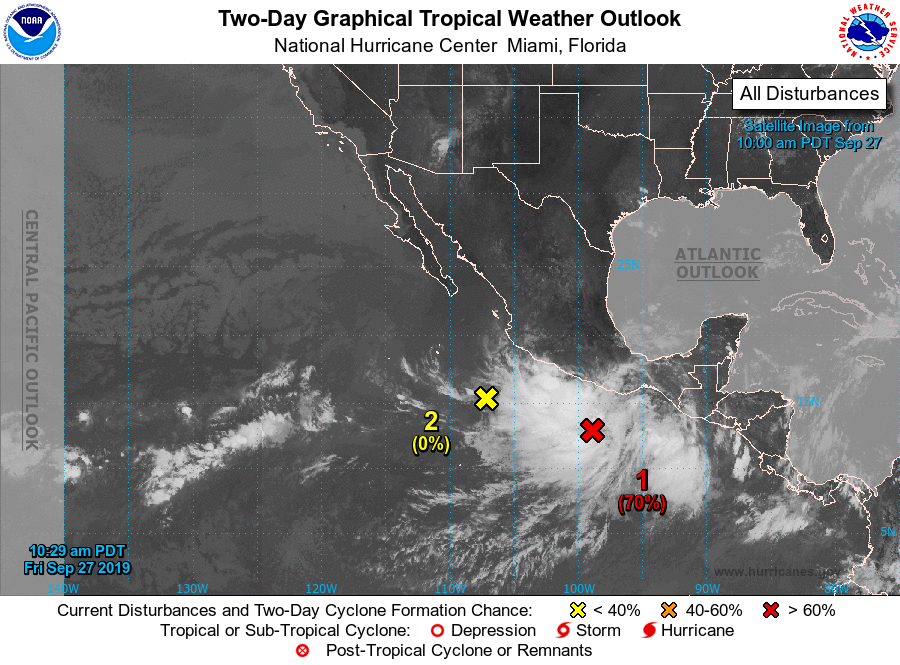
For the eastern North Pacific...east of 140 degrees west longitude:
1. A low pressure system appears to be forming a few hundred miles
south-southeast of Acapulco, Mexico. Although the associated shower
and thunderstorm activity is not well organized, this system is
likely to become a tropical depression or tropical storm during the
next couple of days while it moves west-northwestward to
northwestward at about 10 mph near the southern and southwestern
coast of Mexico. Interests along this portion of the coast should
monitor the progress of the disturbance since tropical storm watches
or warnings could be required at any time during the next couple of
days. Regardless of development, heavy rainfall, with the
possibility of flash flooding and mudslides, is expected near the
southern and southwestern coast of Mexico during the next few days.
* Formation chance through 48 hours...high...70 percent.
* Formation chance through 5 days...high...80 percent.
2. A small area of low pressure located a few hundred miles southwest
of Manzanillo, Mexico, is producing very little shower activity.
The low is expected to be absorbed by the larger weather
disturbance near the coast of Mexico during the next day or so, and
therefore development is not expected.
* Formation chance through 48 hours...low... near 0 percent.
* Formation chance through 5 days...low...near 0 percent.
3. An area of low pressure is expected to form over the far
southwestern portion of the eastern North Pacific by early next
week. Some gradual development is possible thereafter while the
system drifts slowly eastward or northeastward.
* Formation chance through 48 hours...low...near 0 percent.
* Formation chance through 5 days...low...30 percent.
Forecaster Berg/Hagen