ZCZC MIATWOEP ALL
TTAA00 KNHC DDHHMM
Tropical Weather Outlook
NWS National Hurricane Center Miami FL
1100 PM PDT Mon Sep 16 2019
For the eastern North Pacific...east of 140 degrees west longitude:
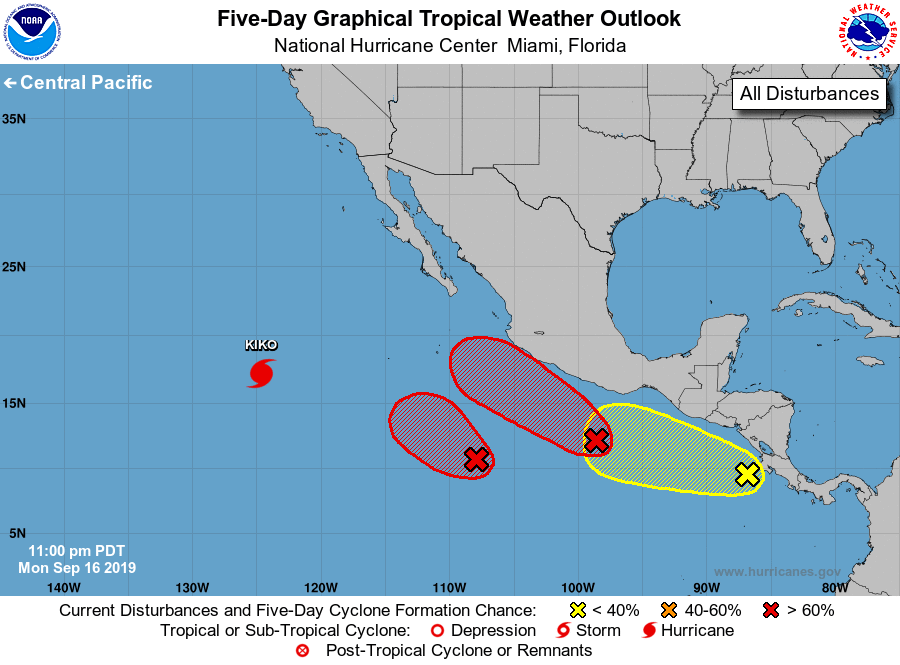
The National Hurricane Center is issuing advisories on Hurricane
Kiko, located over the southwestern part of the basin.
1. Showers and thunderstorms remain limited in association with a
well-defined area of low pressure located about 650 miles
south-southwest of Manzanillo, Mexico. Any significant increase in
the thunderstorm activity would lead to the formation of a tropical
depression later today or tonight, while the disturbance moves
west-northwestward or northwestward.
* Formation chance through 48 hours...high...90 percent.
* Formation chance through 5 days...high...90 percent.
2. Recent satellite-derived wind data indicate that the large area of
low pressure located a few hundred miles south-southeast of
Acapulco, Mexico, is becoming better organized. If this development
trend continues, then a tropical depression or tropical storm could
form later today or tonight. This system will continue to move
west-northwest near or just offshore of the coast of Mexico for the
next few days. Interests along the southwestern coast of Mexico
should monitor the progress of this system.
* Formation chance through 48 hours...high...90 percent.
* Formation chance through 5 days...high...90 percent.
3. Disorganized cloudiness and showers near and just west of Central
America are associated with a tropical wave. Gradual development of
this system is possible during the next several days while the wave
moves westward or west-northwestward at 5 to 10 mph. Locally heavy
rainfall is possible along the coasts of El Salvador, Guatemala
and southeastern Mexico during the next few days.
* Formation chance through 48 hours...low...10 percent.
* Formation chance through 5 days...low...30 percent.
Forecaster Latto