ZCZC MIATWOAT ALL
TTAA00 KNHC DDHHMM
Tropical Weather Outlook
NWS National Hurricane Center Miami FL
800 AM EDT Sat Sep 14 2019
For the North Atlantic...Caribbean Sea and the Gulf of Mexico:
The National Hurricane Center is issuing advisories on Tropical
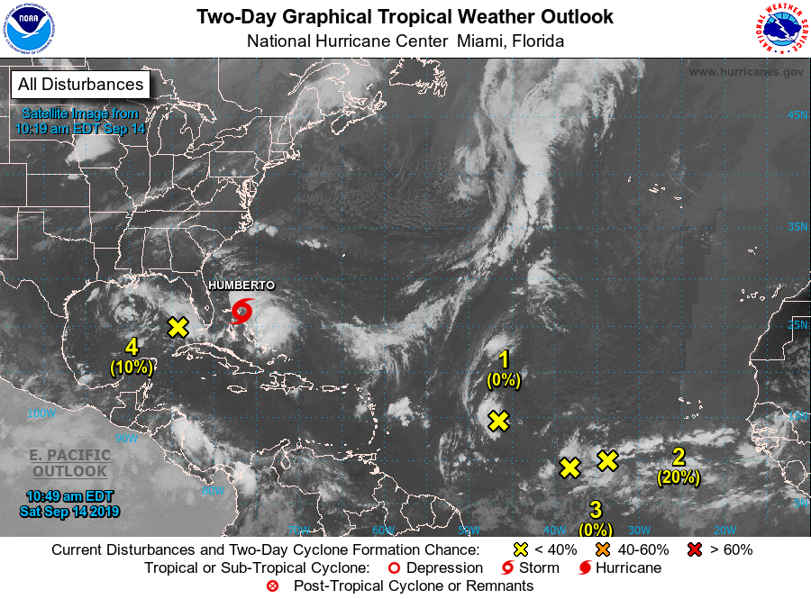
Storm Humberto, centered just east of the northwestern Bahamas.
1. A fast-moving tropical wave is located about 950 miles east
of the Lesser Antilles. This system is producing limited shower
activity, and significant development of this system is not
anticipated during the next several days while it moves
quickly westward.
* Formation chance through 48 hours...low...0 percent.
* Formation chance through 5 days...low...10 percent.
2. An elongated area of disturbed weather is located about 650 miles
southwest of the Cabo Verde Islands. Gradual development of this
system is possible during the next several days, and a tropical
depression could form early next week while it moves westward
across the tropical Atlantic.
* Formation chance through 48 hours...low...20 percent.
* Formation chance through 5 days...medium...60 percent.
3. The area of disturbed weather that was located midway between the
Lesser Antilles and the Cabo Verde Islands has merged with the
easternmost tropical wave mentioned above. Development of the
original disturbance is no longer anticipated.
* Formation chance through 48 hours...low...near 0 percent.
* Formation chance through 5 days...low...near 0 percent.
4. A large area of showers and thunderstorms over the eastern Gulf of
Mexico is primarily associated with a upper-level low pressure
area. Only slow development of this system is likely during the
next couple of days. However, conditions could become more
conducive for development early next week as the system moves
over the western Gulf of Mexico.
* Formation chance through 48 hours...low...near 10 percent.
* Formation chance through 5 days...low...30 percent.
Forecaster Brown